
Through market attractiveness analysis, total addressable market evaluation, company benchmarking matrices, interactive Excel dashboards, expanded supply chain intelligence, emerging startup coverage, and detailed product insights, The Business Research Company’s 2026 market reports provide more actionable and strategically valuable research.
Satellite Imagery Market Size Forecast: How Large Could The Market Become By 2030?
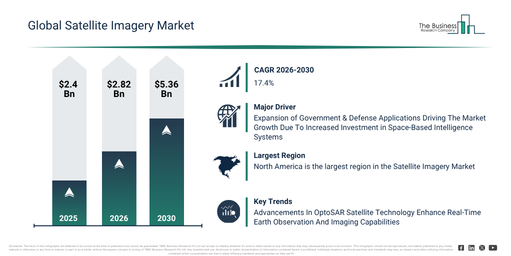
The satellite imagery market has seen rapid expansion in recent years. Its value is anticipated to rise from $2.4 billion in 2025 to $2.82 billion in 2026, at a compound annual growth rate (CAGR) of 17.2%. Factors contributing to this historical growth include an escalating demand for geospatial intelligence data, increased defense surveillance requirements, the broadening of environmental monitoring programs, improvements in satellite sensor technologies, and the growing use of satellite-based mapping applications.
The satellite imagery market is projected for significant expansion in the coming years, anticipated to reach $5.36 billion by 2030, exhibiting a compound annual growth rate (CAGR) of 17.4%. This growth is attributable to heightened investments in next-generation earth observation satellites, an increasing need for real-time monitoring and analytics solutions, the expansion of smart city and infrastructure planning initiatives, the rising adoption of satellite imagery for climate resilience programs, and growing government and commercial space sector investments. Key trends during this period encompass the wider adoption of high-resolution earth observation imagery, an escalating demand for defense and intelligence surveillance applications, the expansion of satellite-based disaster response and emergency management programs, increasing utilization of satellite imagery for agriculture and natural resource monitoring, and the growing deployment of multi-sensor optical, radar, and infrared imaging technologies.
Download A Free Sample Report For Comprehensive Market Insights:
https://www.thebusinessresearchcompany.com/sample_request?id=46890567&type=smp
Satellite Imagery Market Expansion Drivers: What Is Shaping Future Growth?
The increase in government and defense applications is projected to drive the growth of the satellite imagery market. These applications involve the deployment of space-based optical and sensing technologies by military agencies and public institutions for surveillance, reconnaissance, border monitoring, and national security intelligence purposes. The rise in these applications stems from a growing need for real-time surveillance and secure intelligence gathering to reinforce border security, optimize mission planning, and enhance rapid response capabilities. A surge in government and defense investment directly amplifies the demand for advanced satellite imagery capabilities, given that high-resolution, real-time geospatial data is essential for mission planning, threat detection, and battlefield situational awareness. For example, in May 2023, the Congressional Research Service (CRS), a US-based nonpartisan agency, reported that the U.S. Department of Defense’s fiscal year 2024 budget requested $26.1 billion for space-based systems, an increase of $4.4 billion, or 20%, compared to the fiscal year 2023 enacted level. Thus, the expansion of government and defense applications is a key driver for the satellite imagery market’s growth.
Satellite Imagery Market Segment Analysis And Revenue Opportunities
The satellite imagery market covered in this report is segmented –
1) By Type: 0.3 Meter Resolution, 0.5 Meter Resolution, 1 Meter Resolution
2) By Application: Geospatial Data Acquisition, Navigation And Mapping
3) By End User: Government, Defense
Subsegments:
1) By 0.3 Meter Resolution: Urban Planning And Smart Cities, Defense And Intelligence Surveillance, Critical Infrastructure Monitoring
2) By 0.5 Meter Resolution: Agriculture Monitoring, Environmental Monitoring
3) By 1 Meter Resolution: Regional Planning And Development, Large Scale Environmental Studies, Weather And Climate Observation Support
Satellite Imagery Market Strategic Trends: What Is Defining The Next Phase Of Growth?
Major companies operating within the satellite imagery market are increasingly focusing on the development of advanced hybrid imaging services, such as OptoSAR technology, to enhance their all-weather Earth observation capabilities and strengthen real-time geospatial intelligence applications. OptoSAR technology represents a comprehensive satellite imaging system that unifies optical imaging with synthetic aperture radar (SAR) functionalities, enabling the capture of high-resolution Earth imagery in both clear and adverse atmospheric conditions, including monitoring at night. As an illustration, in May 2026, GalaxEye, an India-based space technology company, unveiled Drishti, which is recognized as the world’s inaugural OptoSAR satellite platform. This satellite integrates optical and SAR imaging technologies to deliver continuous high-resolution earth observation data during day, night, and cloudy weather. Its applications include defense surveillance, disaster management, agriculture monitoring, and infrastructure tracking.
Satellite Imagery Market Leading Players Shaping Industry Direction
Major companies operating in the satellite imagery market are Google LLC, Airbus SE, L3Harris Technologies Inc., Planet Labs PBC, Telespazio S.p.A., Spire Global Inc., China Great Wall Industry Corporation (CGWIC), BlackSky Technology Inc., ICEYE Oy, ImageSat International N.V., HawkEye 360, Satellogic Inc., Capella Space Corp., SpaceWill Info. Co. Ltd., Umbra Lab Inc., Synspective Inc., European Space Imaging GmbH, Planet Observer SAS, Earth-i Limited, Bhusatyam Technologies Private Limited, Pixalytics Ltd
Access The Complete Satellite Imagery Market Report:
https://www.thebusinessresearchcompany.com/report/satellite-imagery-market-report
Satellite Imagery Market Geographic Analysis: Where Is Demand Growing The Fastest?
North America was the largest region in the satellite imagery market in 2025. Asia-Pacific is expected to be the fastest-growing region in the forecast period. The regions covered in the satellite imagery report are Asia-Pacific, South East Asia, Western Europe, Eastern Europe, North America, South America, Middle East, Africa.
Get in touch with us:
The Business Research Company: https://www.thebusinessresearchcompany.com/
Americas: +1 310-496-7795
Asia: +44 7882 955267 & +91 8897263534
Europe: +44 7882 955267
Email us at: marketing@tbrc.info
Follow us on:
LinkedIn: https://in.linkedin.com/company/the-business-research-company
YouTube: https://www.youtube.com/channel/UC24_fI0rV8cR5DxlCpgmyFQ
Global Market Model: https://www.thebusinessresearchcompany.com/global-market-model

Wasay has over a decade of experience in market research, data modelling, and analytics, with prior experience at GlobalData and Decision Tree Consulting Services. At The Business Research Company , he leads research operations across syndicated studies, customized consulting engagements, and the Global Market Model platform. His professional experience includes supporting organizations such as Boston Consulting Group, KPMG, and Ernst & Young. Wasay holds a degree in Electronics and Communications Engineering, postgraduate management qualifications from International Management Institute Belgium and Indian School of Business and Entrepreneurship, and completed the Integrated Program in Business Analytics from Indian Institute of Management Indore.