Through market attractiveness analysis, total addressable market evaluation, company benchmarking matrices, interactive Excel dashboards, expanded supply chain intelligence, emerging startup coverage, and detailed product insights, The Business Research Company’s 2026 market reports provide more actionable and strategically valuable research.
Lidar In Mapping Market Forecast: What Market Value Is Expected By 2030?
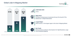
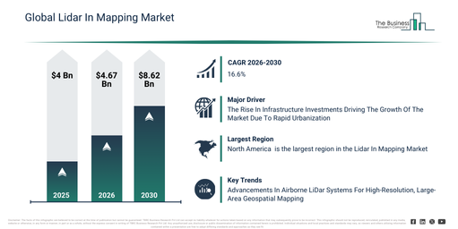
The lidar in mapping market has experienced substantial growth recently. This market is projected to expand from $4 billion in 2025 to $4.67 billion in 2026, demonstrating a compound annual growth rate (CAGR) of 16.8%. Historically, this expansion has been driven by factors such as infrastructure development mapping needs, government geospatial initiatives, innovations in laser scanning, the rise of transportation projects, and the demand for environmental monitoring.
The lidar in mapping market size is anticipated to undergo significant expansion in the coming years, with projections indicating a rise to $8.62 billion by 2030, achieving a compound annual growth rate (CAGR) of 16.6%. This expected growth throughout the forecast period stems from factors such as advancements in smart city development, the broadening scope of autonomous navigation systems, various climate monitoring programs, heightened investment in geospatial analytics, and the increasing uptake of digital twins. Key trends for this period encompass the adoption of drone-based lidar mapping, the integration of AI-driven data processing, the wider application of urban planning tools, the evolution of real-time 3D mapping, and a growing utilization in disaster risk management.
Download A Free Sample Report For Comprehensive Market Insights:
Lidar In Mapping Market Expansion Drivers: What Is Shaping Future Growth?
Increasing investments in infrastructure development are anticipated to advance the growth of light detection and ranging (LiDAR) in the mapping market. These investments refer to the allocation of financial resources toward building, upgrading, and maintaining essential physical and organizational structures. The rise in infrastructure development investments is driven by rapid urbanization, as expanding cities require enhanced transportation, utilities, and public services to support increasing populations and economic activities. Such investments propel the adoption of lidar in mapping by escalating the demand for precise, high-resolution spatial data, which is crucial for efficiently planning, designing, and monitoring complex construction projects. For instance, in July 2024, according to the Office for National Statistics (ONS), a UK-based government department, total investment in the infrastructure sector in 2023 reached $17.3 billion (£13.8 billion) at constant prices, marking a 3.9% increase from 2022. Consequently, the growing investments in infrastructure development are driving the expansion of lidar in the mapping market.
Lidar In Mapping Market Segmentation Trends And Revenue Drivers
The lidar in mapping market covered in this report is segmented –
1) By Component: Hardware, Software, Services
2) By Platform: Drones, Terrestrial, Airborne, Handheld, Backpack
3) By Technology: Terrestrial Light Detection And Ranging (LiDAR), Aerial Light Detection And Ranging (LiDAR), Mobile Light Detection And Ranging (LiDAR), Bathymetric Light Detection And Ranging (LiDAR)
4) By Application: Urban Planning, Environmental Monitoring, Disaster Management, Infrastructure Development, Other Applications
5) By End-User: Government, Construction, Transportation, Utilities, Other End-Users
Subsegments:
1) By Hardware: Laser Scanners, Global Positioning System Units, Inertial Measurement Units (IMU), Cameras, Data Storage Devices
2) By Software: Mapping Software, Data Processing Software, Point Cloud Management Software, Visualization Software, Workflow Automation Software
3) By Services: Consulting Services, Integration And Deployment Services, Training And Education Services, Support And Maintenance Services, Managed Services
Lidar In Mapping Market Strategic Trends: What Is Defining The Next Phase Of Growth?
Leading companies in the light detection and ranging (LiDAR) in the mapping market are concentrating on developing advanced products, such as professional airborne light detection and ranging (LiDAR) systems, to more efficiently acquire high-resolution, large-area geospatial data. Professional airborne light detection and ranging (LiDAR) systems are aircraft-mounted LiDAR solutions integrated with sensors and either a global positioning system or an inertial measurement unit, designed to capture precise, high-resolution geospatial data across extensive areas. For example, in August 2025, Rock Robotic Inc., a technology company based in the US, unveiled ROCK Ultra LiDAR, a next-generation professional airborne LiDAR system engineered to significantly boost the efficiency and simplify large-scale surveying projects. This system incorporates a high-power 1550 nm laser that can capture up to one million points per second and delivers seven returns per pulse, ensuring excellent vegetation penetration and providing survey-grade data with 1 cm horizontal and 2 cm vertical accuracy. Its long-range functionality supports flights up to 450 meters above ground, allowing surveyors to cover 2–3 times more area per flight while simplifying mission planning by enabling safe flight over obstacles. Weighing just 1.4 kg, it is designed for drone compatibility, offering a complete solution for efficient, high-quality mapping and data processing.
#Lidar In Mapping Market Industry Leaders: Which Organizations Are Driving Competition?
Major companies operating in the lidar in mapping market are Hexagon AB, Teledyne Optech Inc., Trimble Inc., SICK AG, Topcon Corporation, Leica Geosystems AG, FARO Technologies Inc., LeiShen Intelligent Systems Company Limited, Velodyne Lidar Inc., Ouster Inc., Ceinsys Tech Limited, Geokno India Private Limited, BPC Consultant India Private Limited, Innoviz Technologies Ltd., YellowScan SAS, Neuvition Inc., Phoenix LiDAR Systems Incorporated, Quanergy Systems Incorporated, Rock Robotic Inc., Aeva Technologies Inc.
Access The Complete Lidar In Mapping Market Report:
Lidar In Mapping Market Global Footprint: Which Region Holds Market Leadership?
North America was the largest region in the light detection and ranging (LiDAR) in the mapping market in 2025. Asia-Pacific is expected to be the fastest-growing region in the forecast period. The regions covered in the lidar in mapping market report are Asia-Pacific, South East Asia, Western Europe, Eastern Europe, North America, South America, Middle East, Africa
Get in touch with us:
The Business Research Company: https://www.thebusinessresearchcompany.com/
Americas: +1 310-496-7795
Asia: +44 7882 955267 & +91 8897263534
Europe: +44 7882 955267
Email us at: marketing@tbrc.info
Follow us on:
LinkedIn: https://in.linkedin.com/company/the-business-research-company
YouTube: https://www.youtube.com/channel/UC24_fI0rV8cR5DxlCpgmyFQ
Global Market Model: https://www.thebusinessresearchcompany.com/global-market-model

Wasay has over a decade of experience in market research, data modelling, and analytics, with prior experience at GlobalData and Decision Tree Consulting Services. At The Business Research Company , he leads research operations across syndicated studies, customized consulting engagements, and the Global Market Model platform. His professional experience includes supporting organizations such as Boston Consulting Group, KPMG, and Ernst & Young. Wasay holds a degree in Electronics and Communications Engineering, postgraduate management qualifications from International Management Institute Belgium and Indian School of Business and Entrepreneurship, and completed the Integrated Program in Business Analytics from Indian Institute of Management Indore.