Featuring market attractiveness scoring, total addressable market sizing, company benchmarking matrices, interactive Excel dashboards, deeper supply chain intelligence, emerging startup tracking, and granular product-level insights, The Business Research Company’s 2026 market reports are built to deliver research that is both more actionable and more strategically valuable.
Unmanned Aerial Vehicle (UAV) Light Detection And Ranging (LiDAR) Mapping Market Growth Analysis: How Will Revenue Trend Over The Forecast Period?
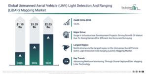
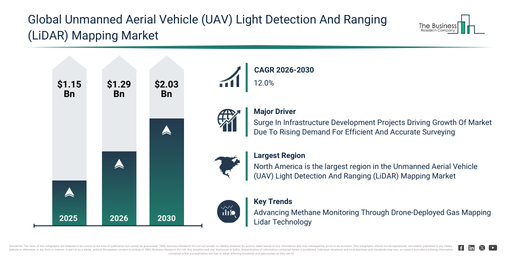
The unmanned aerial vehicle (UAV) light detection and ranging (lidar) mapping market has experienced substantial growth recently. It is projected to expand from $1.15 billion in 2025 to $1.29 billion in 2026, at a compound annual growth rate (CAGR) of 12.2%. Historically, this expansion can be attributed to the early development of UAV platforms for aerial surveying, the integration of lidar sensors for high-resolution mapping, financial support from government and industry for geospatial and environmental monitoring programs, the implementation of onboard data storage and processing systems, and the initial use of GPS and IMU components for precise georeferencing.
The unmanned aerial vehicle (UAV) light detection and ranging (lidar) mapping market is projected to experience swift expansion over the coming years. This market is set to reach $2.03 billion by 2030, exhibiting a compound annual growth rate (CAGR) of 12.0%. This anticipated growth is driven by several factors, including a heightened need for precise lidar mapping in infrastructure and environmental initiatives, the extension of UAV lidar offerings for charting coastal regions, rivers, and historical sites, the implementation of sophisticated onboard data processing and storage technologies, the creation of advanced UAV platforms featuring integrated lidar sensors, and enhanced partnerships between drone producers and geospatial service firms for extensive mapping endeavors. Key trends anticipated during this period encompass a growing requirement for high-resolution mapping of terrain and vegetation, an increase in multi-rotor and hybrid UAV platforms for diverse uses, the proliferation of entirely and partially automated UAV lidar systems, a surge in the deployment of environmental and infrastructure monitoring tools, and improved integration of GIS and mapping software for data interpretation.
Get A Free Sample Report With In-Depth Market Insights:
Unmanned Aerial Vehicle (UAV) Light Detection And Ranging (LiDAR) Mapping Market Growth Catalysts And Demand Drivers
The expansion of infrastructure development initiatives is anticipated to propel the unmanned aerial vehicle (UAV) light detection and ranging (LiDAR) mapping market forward. These initiatives encompass the design, construction, and enhancement of vital physical systems such as roads, bridges, railways, airports, power grids, and water utilities, all of which are essential for economic progress and societal welfare. The surge in such projects stems from a rising demand for contemporary urban amenities and robust public services to accommodate growing populations and economic expansion. UAV LiDAR systems play a pivotal role in infrastructure development by delivering rapid, accurate, and comprehensive mapping and surveying solutions. They facilitate the creation of precise 3D models of construction areas, landscapes, and existing structures, thereby assisting planners and engineers in effective site evaluation and infrastructure design. For instance, in February 2024, the UK’s Infrastructure and Projects Authority indicated a planned investment of $201.52 billion (£164 billion) for major infrastructure and construction projects in 2024–25, an increase from the previous year that highlights robust economic activity. Furthermore, over the coming decade, total sector investments are forecast to range from $858.1 billion (£700 billion) to $953.25 billion (£775 billion), signaling consistent long-term expansion and progress. Consequently, the rising number of infrastructure development projects is a key factor driving the growth of the unmanned aerial vehicle (UAV) light detection and ranging (LiDAR) mapping market.
Unmanned Aerial Vehicle (UAV) Light Detection And Ranging (LiDAR) Mapping Market Segment Analysis And Revenue Potential
The unmanned aerial vehicle (uav) light detection and ranging (lidar) mapping market covered in this report is segmented –
1) By Type: 3D Visualization, Digital Twin Creation, Vegetation Mapping, Contour Mapping, Volumetric Analysis
2) By Type Of Unmanned Aerial Vehicle (UAVs): Fixed-Wing Unmanned Aerial Vehicle (UAVs), Multi-Rotor Unmanned Aerial Vehicle (UAVs), Hybrid Unmanned Aerial Vehicle (UAVs)
3) By Light Detection And Ranging (LiDAR) Technology: Airborne Light Detection And Ranging (LiDAR), Mobile Light Detection And Ranging (LiDAR)
4) By Level Of Automation: Fully Automated, Partially Automated, Manual Operation
5) By End-User Industry: Agriculture, Construction, Forestry, Mining, Environmental Monitoring
Subsegments:
1) By 3D Visualization: Terrain Modeling, Building Modeling, Infrastructure Visualization, Landscape Visualization
2) By Digital Twin Creation: Urban Digital Twins, Industrial Digital Twins, Infrastructure Digital Twins, Environmental Digital Twins
3) By Vegetation Mapping: Canopy Height Measurement, Biomass Estimation, Species Classification, Health and Stress Detection
4) By Contour Mapping: Elevation Contours, Slope Analysis, Watershed Delineation, Floodplain Mapping
5) By Volumetric Analysis: Stockpile Volume Measurement, Excavation Volume Calculation, Quarry Volume Estimation, Biomass Volume Assessment
Unmanned Aerial Vehicle (UAV) Light Detection And Ranging (LiDAR) Mapping Market Trends Shaping Long-Term Demand
Leading companies in the unmanned aerial vehicle (UAV) Light Detection and Ranging (LiDAR) mapping market are increasingly advancing technologies like Gas Mapping LiDAR (GML) to strengthen their competitive standing. GML utilizes laser-based sensing systems to accurately detect and measure gas emissions across complex and remote terrains. For instance, in May 2025, Bridger Photonics, a U.S.-based energy technology company, introduced a drone-mounted GML system specifically designed for rapid and precise identification of methane emissions in hard-to-access areas, including offshore oil platforms, LNG facilities, and intricate pipeline networks. This upgraded drone-based system, which was previously deployed using manned aircraft, provides faster data acquisition, improved accuracy, reduced operational downtime, and enhanced worker safety by minimizing the requirement for on-site inspections. This advancement represents a significant step forward in methane monitoring, enabling operators to effectively manage emissions in remote and challenging environments while supporting global efforts to reduce greenhouse gases and ensure environmental compliance.
Unmanned Aerial Vehicle (UAV) Light Detection And Ranging (LiDAR) Mapping Market Key Players Shaping Industry Direction
Major companies operating in the unmanned aerial vehicle (UAV) light detection and ranging (lidar) mapping market are Teledyne Technologies Incorporated, Hexagon Aktiebolag, Trimble Incorporated, Leica Geosystems Aktiengesellschaft, Faro Technologies Incorporated, Microdrones GmbH, Westwood Professional Services Incorporated, RaSmith Incorporated, Delair Société par Actions Simplifiée, Firmatek Limited Liability Company, Phantom Artificial Intelligence Incorporated, LeddarTech Incorporated, South West Surveys Limited, Quanergy Systems Incorporated, Innoviz Technologies Limited, YellowScan Société par Actions Simplifiée, Dielmo Three Dimensional, Phoenix LiDAR Systems Incorporated, Quantum-Systems GmbH, Aeva Technologies Incorporated
View The Full Unmanned Aerial Vehicle (UAV) Light Detection And Ranging (LiDAR) Mapping Market Report:
Unmanned Aerial Vehicle (UAV) Light Detection And Ranging (LiDAR) Mapping Market Top Region By Revenue And Market Share
North America was the largest region in the unmanned aerial vehicle (UAV) light detection and ranging (LiDAR) mapping market in 2025. Asia-Pacific is expected to be the fastest-growing region in the forecast period. The regions covered in the unmanned aerial vehicle (UAV) light detection and ranging (lidar) mapping market report are Asia-Pacific, South East Asia, Western Europe, Eastern Europe, North America, South America, Middle East, Africa.
Reach Out To Our Team:
The Business Research Company: https://www.thebusinessresearchcompany.com/
Americas: +1 310-496-7795
Asia: +44 7882 955267 & +91 8897263534
Europe: +44 7882 955267
Email us at: marketing@tbrc.info
Follow us on:
LinkedIn: https://in.linkedin.com/company/the-business-research-company
YouTube: https://www.youtube.com/channel/UC24_fI0rV8cR5DxlCpgmyFQ
Global Market Model: https://www.thebusinessresearchcompany.com/global-market-model

Wasay has over a decade of experience in market research, data modelling, and analytics, with prior experience at GlobalData and Decision Tree Consulting Services. At The Business Research Company , he leads research operations across syndicated studies, customized consulting engagements, and the Global Market Model platform. His professional experience includes supporting organizations such as Boston Consulting Group, KPMG, and Ernst & Young. Wasay holds a degree in Electronics and Communications Engineering, postgraduate management qualifications from International Management Institute Belgium and Indian School of Business and Entrepreneurship, and completed the Integrated Program in Business Analytics from Indian Institute of Management Indore.