
The Business Research Company’s 2026 market reports combine market attractiveness scoring, total addressable market sizing, company benchmarking matrices, interactive Excel dashboards, deeper supply chain intelligence, emerging startup tracking, and granular product-level insights to deliver research that is more actionable and strategically valuable.
Satellite Data Service For Agriculture Market Value Projected To Grow At A 14.4% Compound Annual Growth Rate Through 2030
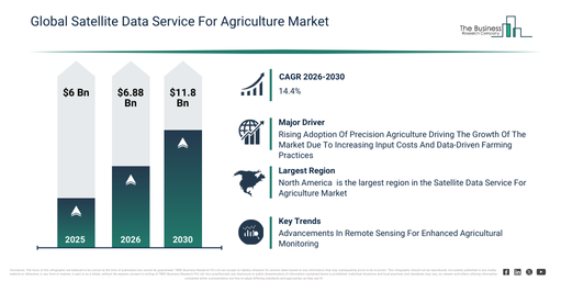
The satellite data service for agriculture market has seen rapid growth in recent years. This market is expected to expand from $6 billion in 2025 to $6.88 billion in 2026, achieving a compound annual growth rate (CAGR) of 14.7%. The historical expansion of this market can be attributed to the early uptake of remote sensing on large farms, initial government funding for agricultural satellite initiatives, increasing understanding of the advantages of crop monitoring, restricted availability of ground-based analytics, and a traditional reliance on manual field scouting.
The satellite data service for agriculture market is anticipated to experience substantial expansion over the coming years. Its valuation is projected to reach $11.8 billion by 2030, demonstrating a compound annual growth rate (CAGR) of 14.4%. This projected growth during the forecast period stems from several key factors, including the escalating requirement for climate-resilient farming insights, a surge in demand for automated geospatial analytics, the broadening of satellite coverage into rural territories, the deepening integration of artificial intelligence with satellite datasets, and a broader move towards data-driven precision agriculture. Significant trends anticipated for this period encompass a heightened demand for weather-integrated satellite advisory services, an expansion of satellite-powered risk assessments for crop insurance, a greater uptake of farm-level geospatial solutions for decision support, an increase in precision input planning informed by satellite vegetation analytics, and the creation of satellite-supported systems for early pest and disease detection.
Evaluate The Satellite Data Service For Agriculture Market Report Before You Buy With A Free Sample:
Satellite Data Service For Agriculture Market Growth Driver Analysis For The 2026–2030 Forecast Period
The increasing understanding of precision agriculture is anticipated to drive the expansion of the satellite data service for the agriculture market. Precision agriculture involves employing data-led tools and methods to manage field variations and enhance the utilization of resources like seeds, fertilizers, and water. This rising awareness stems from its capacity to maximize crop yields and minimize waste of resources. The satellite data service facilitates precision agriculture by offering prompt, field-specific insights, including crop health monitoring, soil moisture evaluation, yield forecasting, and vegetation mapping, empowering farmers to make informed, location-specific choices. An example of this trend is seen in July 2024, where, as per the Mississippi Soybean Promotion Board, a US-based state-level agricultural organization, the percentage of farms utilizing variable rate technology (VRT) for any input increased from 2.8% to 4.9% over three years. Consequently, the expanding recognition of precision agriculture’s advantages is fueling the expansion of the satellite data service for the agriculture market.
Satellite Data Service For Agriculture Market Segmentation Breakdown: Primary And Secondary Categories
The satellite data service for agriculture market covered in this report is segmented –
1) By Type Of Satellite Service: Optical Satellite Imagery, Radar Satellite Imagery, Multispectral And Hyperspectral Imagery, Infrared Imaging, Gridded Weather Data
2) By Deployment Model: Cloud-Based Services, On-Premise Solutions, Hybrid Solutions
3) By Satellite Data Processing Features: Data Compression And Storage, Real-Time Data Processing, Analytical Tools And Software, Data Visualization Solutions, Machine Learning And Artificial Intelligence Integration
4) By Application: Mapping, Vegetation And Crop Health Monitoring, Crop Yield Management, Other Applications
5) By End User: Farmers And Agricultural Producers, Agricultural Consultants, Government And Regulatory Bodies, Research And Educational Institutions, Agri-Tech Companies
Subsegments:
1) By Optical Satellite Imagery Services: High Resolution Optical Imagery, Medium Resolution Optical Imagery, Low Resolution Optical Imagery
2) By Radar Satellite Imagery Services: Synthetic Aperture Radar Imagery, Interferometric Radar Imagery, Polarimetric Radar Imagery
3) By Multispectral and Hyperspectral Imagery Services: Shortwave Infrared Imagery, Near Infrared Imagery, Visible Spectrum Imagery
4) By Infrared Imaging Services: Thermal Infrared Imaging, Near Infrared Imaging, Mid Infrared Imaging
5) By Gridded Weather Data Services: Precipitation Data, Temperature Data, Soil Moisture Data, Evapotranspiration Data
Satellite Data Service For Agriculture Market Industry Trends: New Developments From Leading Companies
Leading companies in the satellite data service for the agriculture market are concentrating on advancing novel technologies, such as remote sensing, to gather and evaluate crop status, soil properties, and ecological factors without direct physical interaction. Remote sensing technology encompasses the process of collecting information about the Earth’s surface and atmosphere from a distance, typically utilizing satellites, drones, or aircraft, without making direct physical contact. For instance, in Mar 2023, InnerPlant, a US-based technology company, in collaboration with Satellogic Inc., a US-based earth observation company, introduced Detecting Human-Made Crop Signals from Space. This system offers enhanced accuracy in monitoring farming activities by identifying subtle indicators like fertilizer application, water usage, and soil changes that standard imaging cannot detect. This capability significantly improves decision-making by allowing real-time tracking of input efficiency, crop stress levels, and sustainability compliance over extensive areas. It supports farmers in optimizing resources, decreasing environmental impact, and increasing yields, while also providing governments and agribusinesses with verifiable data for policy enforcement and supply chain transparency.
Who Are The Top Competitors In The Satellite Data Service For Agriculture Market?
Major companies operating in the satellite data service for agriculture market are Airbus SE, Planet Labs PBC, EOS Data Analytics Inc., Pixxel Space Technologies, CropX Inc., Ceres Imaging Inc., SatSure Analytics Pvt. Ltd., OneSoil AG, Kermap, AgroScout, Earth-i Ltd, SI Imaging Services (SIIS), DataFarming, Farmonaut, FarmQA, Agricolus Srl, Avant Global LLC, Esper Satellite Imagery, Agremo, FarmiSpace
Access The Satellite Data Service For Agriculture Market Report For Complete Segment-Level Analysis:
Which Region Leads The Satellite Data Service For Agriculture Market, And Which Regions Are Covered?
North America was the largest region in the satellite data service for agriculture market in 2025. Asia-Pacific is expected to be the fastest-growing region in the forecast period. The regions covered in the satellite data service for agriculture market report are Asia-Pacific, South East Asia, Western Europe, Eastern Europe, North America, South America, Middle East, Africa.
Reach Out To Our Team:
The Business Research Company: https://www.thebusinessresearchcompany.com/
Americas: +1 310-496-7795
Asia: +44 7882 955267 & +91 8897263534
Europe: +44 7882 955267
Email us at: marketing@tbrc.info
Follow us on:
LinkedIn: https://in.linkedin.com/company/the-business-research-company
YouTube: https://www.youtube.com/channel/UC24_fI0rV8cR5DxlCpgmyFQ
Global Market Model: https://www.thebusinessresearchcompany.com/global-market-model

Wasay has over a decade of experience in market research, data modelling, and analytics, with prior experience at GlobalData and Decision Tree Consulting Services. At The Business Research Company , he leads research operations across syndicated studies, customized consulting engagements, and the Global Market Model platform. His professional experience includes supporting organizations such as Boston Consulting Group, KPMG, and Ernst & Young. Wasay holds a degree in Electronics and Communications Engineering, postgraduate management qualifications from International Management Institute Belgium and Indian School of Business and Entrepreneurship, and completed the Integrated Program in Business Analytics from Indian Institute of Management Indore.

