
The Business Research Company’s 2026 market reports are designed to deliver research that is more actionable and strategically valuable. Key offerings include market attractiveness scoring, total addressable market sizing, company benchmarking matrices, interactive Excel dashboards, deeper supply chain intelligence, emerging startup tracking, and granular product-level insights.
Drone-Based Floodplain Mapping Market Size 2026: Valuation, Growth Rate And Forecast To 2030
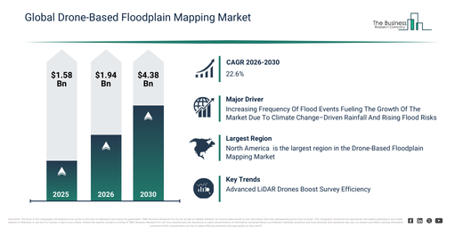
The drone-based floodplain mapping market has experienced substantial growth in recent years. It will grow from $1.58 billion in 2025 to $1.94 billion in 2026 at a compound annual growth rate (CAGR) of 22.8%. This historical growth is primarily due to several factors, including the increasing occurrence of flood events, the past reliance on manual surveying techniques, a growing demand for precise hazard mapping, the rising adoption of drone imaging tools, and the limited access to high-risk regions.
The drone-based floodplain mapping market size is anticipated to expand significantly in the next few years. It will grow to $4.38 billion in 2030 at a compound annual growth rate (CAGR) of 22.6%. This expansion during the forecast period is driven by the widening scope of predictive flood modeling, greater financial commitments to climate resilience initiatives, the increasing deployment of lidar-equipped drones, governments’ heightened emphasis on reducing disaster risks, and the broader integration of real-time aerial data platforms. Significant developments anticipated during this period encompass a surging need for high-resolution floodplain mapping, more frequent application of drone-based hazard zone identification, the expanding embrace of rapid aerial flood assessment, the extension of drone-supported urban planning and infrastructure mapping, and enhanced precision in environmental monitoring facilitated by aerial imaging.
Get A Free Sample Of The Drone-Based Floodplain Mapping Market Report 2026:
What Is Driving The Growth Of The Drone-Based Floodplain Mapping Market?
The escalating frequency of flood events is anticipated to propel the growth of the drone-based floodplain mapping market moving forward. Flood events describe situations where water from rivers, lakes, oceans, or intense rainfall overflows onto normally dry land, causing either temporary or prolonged submersion. The uptick in flood occurrences stems from climate change, which intensifies rainfall and leads to excessive water accumulation in rivers and low-lying areas, resulting in more frequent inundation. Drone-based floodplain mapping addresses flood events by providing high-precision terrain and water flow information, making it an ideal solution for identifying flood-prone regions. It reduces manual surveying efforts by delivering accurate 3D elevation models and real-time insights, thereby improving flood risk assessment and mitigation planning. For instance, in December 2023, according to the UK Health Security Agency, a UK-based government agency, the number of people in the UK at risk of flooding is expected to grow by 61% by 2050 and further to 118% by 2080. Therefore, the increasing frequency of flood events is driving the expansion of the drone-based floodplain mapping market.
How Is The Drone-Based Floodplain Mapping Market Segmented?
The drone-based floodplain mapping market covered in this report is segmented –
1) By Solution: Hardware, Software, Services
2) By Platform: Fixed-Wing Drones, Rotary-Wing Drones, Hybrid Drones
3) By Application: Flood Risk Assessment, Disaster Management, Urban Planning, Environmental Monitoring, Other Applications
4) By End-User: Government And Public Safety, Agriculture, Insurance, Construction, Other End-Users
Subsegments:
1) By Hardware: Unmanned Aerial Vehicles, Light Detection And Ranging Systems (LiDAR Systems), Multispectral Or Hyperspectral Cameras, Global Navigation Satellite System Or Global Positioning System Equipment, Thermal Sensors, Drone Payloads
2) By Software: Geographic Information System (GIS) Software, 3D Photogrammetry Software, Data Processing And Analytics Platforms, Mapping And Visualization Tools, Predictive Modeling Software
3) By Services: Aerial Surveying Services, Data Collection And Processing Services, Risk Assessment And Analysis Services, Consulting And Advisory Services, Maintenance And Support Services
What Are The Latest Trends In The Drone-Based Floodplain Mapping Market?
Leading companies within the drone-based floodplain mapping sector are prioritizing the development of advanced products, such as integrated light detection and ranging (LiDAR) systems. This focus aims to enhance data accuracy, improve survey efficiency, and reduce both manual processing time and associated costs. Integrated LiDAR systems are sophisticated sensor packages deployed on drones that employ laser light to accurately measure distances to the Earth’s surface, thereby generating exceptionally precise 3D elevation models of terrain, even when obscured by vegetation. For example, in March 2024, Wingtra AG, a Switzerland-based vertical take-off and landing (VTOL) drone producer, unveiled a new drone LiDAR solution. This offering integrates a Wingtra-engineered LiDAR sensor with the WingtraOne Generation Two (GEN II) drone, designed to deliver highly precise, efficient, and user-friendly mapping capabilities. This comprehensive solution significantly cuts down on field time, minimizes post-processing efforts, and supplies consistent, high-quality three-dimensional (3D) point cloud data, even in complex terrains. Its distinctive attributes include a one-minute initialization process, automated flight patterns, and minimal noise capture, which together ensure dependable and repeatable results across various survey conditions.
Who Are The Key Players In The Drone-Based Floodplain Mapping Market?
Major companies operating in the drone-based floodplain mapping market are SZ DJI Technology Co. Ltd., Esri Inc., Topcon Positioning Systems Inc., Terra Drone Corporation, Autel Robotics Co. Ltd., Skydio Inc., Quantum-Systems GmbH, Parrot SA, Microdrones GmbH, Pix4D SA, Wingtra AG, Delair SAS, AgEagle Aerial Systems Inc., FlyGuys Inc., GreenValley International LLC, GeoCue Group Inc., Draganfly Inc., Darling Geomatics Inc., Inspired Flight Technologies Inc., IdeaForge Technology Pvt. Ltd.
Read The Complete Drone-Based Floodplain Mapping Market Report 2026:
Which Region Is The Largest In The Drone-Based Floodplain Mapping Market?
North America was the largest region in the drone-based floodplain mapping market in 2025. Asia-Pacific is expected to be the fastest-growing region in the forecast period. The regions covered in the drone-based floodplain mapping market report are Asia-Pacific, South East Asia, Western Europe, Eastern Europe, North America, South America, Middle East, Africa.
Reach Out To Our Team:
The Business Research Company: https://www.thebusinessresearchcompany.com/
Americas: +1 310-496-7795
Asia: +44 7882 955267 & +91 8897263534
Europe: +44 7882 955267
Email us at: marketing@tbrc.info
Follow us on:
LinkedIn: https://in.linkedin.com/company/the-business-research-company
YouTube: https://www.youtube.com/channel/UC24_fI0rV8cR5DxlCpgmyFQ
Global Market Model: https://www.thebusinessresearchcompany.com/global-market-model

Wasay has over a decade of experience in market research, data modelling, and analytics, with prior experience at GlobalData and Decision Tree Consulting Services. At The Business Research Company , he leads research operations across syndicated studies, customized consulting engagements, and the Global Market Model platform. His professional experience includes supporting organizations such as Boston Consulting Group, KPMG, and Ernst & Young. Wasay holds a degree in Electronics and Communications Engineering, postgraduate management qualifications from International Management Institute Belgium and Indian School of Business and Entrepreneurship, and completed the Integrated Program in Business Analytics from Indian Institute of Management Indore.

