
With a focus on actionable insights and strategic value, The Business Research Company’s 2026 market reports include market attractiveness scoring, total addressable market sizing, company benchmarking matrices, interactive Excel dashboards, deeper supply chain intelligence, emerging startup tracking, and granular product-level insights.
Terrestrial Laser Scanning Market Size Outlook: A $7.23 Billion Market By 2030, Growing At 0% Annually
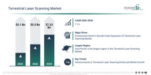
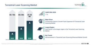
The terrestrial laser scanning market has experienced robust expansion in recent years. Its value is projected to increase from $5.1 billion in 2025 to $5.5 billion in 2026, exhibiting a compound annual growth rate (CAGR) of 7.8%. This historical growth was driven by factors such as increased surveying and mapping activities, a rise in infrastructure development projects, broader adoption of BIM workflows, the demand for precise land measurement, and advancements in laser scanning hardware.
The terrestrial laser scanning market size is anticipated to undergo significant expansion in the upcoming years. It is foreseen to reach $7.23 billion by 2030, demonstrating a compound annual growth rate (CAGR) of 7.1%. The expansion during the forecast period can be ascribed to its integration with AI-based data analytics, the proliferation of smart city initiatives, its increasing application in mining and environmental monitoring, the necessity for real-time 3D data capture, and developments in digital construction technologies. Principal trends for the forecast period encompass the rising uptake of terrestrial laser scanning in infrastructure monitoring, its increasing deployment for high-accuracy topographical mapping, a growing need for 3D point cloud data in construction projects, the extension of laser scanning services for forestry and environmental surveys, and the assimilation of terrestrial laser scanning data with advanced modeling and visualization tools.
Make Data-Driven Decisions With A Free Terrestrial Laser Scanning Market Sample Report:
Key Demand Driver Expected To Lift Terrestrial Laser Scanning Market Revenue
The expanding construction industry is anticipated to fuel the advancement of the terrestrial laser scanning market moving ahead. This sector covers the conceptualization, architectural design, building, and upkeep of physical structures, including residential properties, commercial establishments, and infrastructure initiatives. An increase in construction activities indicates economic expansion, a growing urban population, and a greater need for infrastructure and real estate projects. Within the construction domain, terrestrial laser scanning offers exceptionally detailed and precise three-dimensional site visualizations, enabling accurate measurements, quality assurance, and ongoing project oversight. As an illustration, the Australian Bureau of Statistics, an Australian government administration, reported in July 2023 that during the March quarter of 2023, the total number of dwellings actively being built climbed to 240,813, an increase from 240,065 recorded in 2022. Of these, new houses accounted for 103,778 units, in contrast to 101,240 in the preceding year. Consequently, the expanding construction industry is serving as a key impetus for the expansion of the terrestrial laser scanning market.
Exploring The Terrestrial Laser Scanning Market Through Its Key Segments
The terrestrial laser scanning market covered in this report is segmented –
1) By Solution: Scanning Systems, Scanning Services
2) By Technology: Phase Shift Scanning, Mobile Scanning, Pulse Based Scanning
3) By Application: Building Information Modeling, Forestry And Agricultural Survey, Topographical Survey, Mining Survey, Research And Engineering, Construction Survey, Other Applications
Subsegments:
1) By Scanning Systems: 3D Laser Scanners, Static Laser Scanners, Mobile Laser Scanners, Handheld Laser Scanners
2) By Scanning Services: Data Collection Services, Data Processing Services, 3D Modeling Services, Consulting And Integration Services
New Trends Redefining Competition In The Terrestrial Laser Scanning Market
Leading companies within the terrestrial laser scanning market are prioritizing the development of advanced laser scanning technology to boost the precision, efficiency, and versatility of spatial data collection. This advanced laser scanning technology involves utilizing high-precision laser systems to capture comprehensive 3D measurements of surfaces and structures. For example, in May 2023, Trimble Inc., a US-based technology company, introduced the X9 3D laser scanner, a reality capture solution specifically designed for professionals in surveying, construction, and engineering. As the newest addition to Trimble’s laser scanning product line, it delivers improved performance across diverse operating conditions. The X9 incorporates innovations such as Trimble X-Drive technology for automated instrument calibration, survey-grade self-leveling capabilities, and a laser pointer for accurate georeferencing. Building upon the success of the industry-proven X7, the X9 offers an extended scanning range, enhanced accuracy, shorter scan durations, and superior sensitivity. This elevated performance allows the X9 to effortlessly capture challenging dark or reflective surfaces, making it highly adaptable for applications across industries such as surveying, construction, rail, mining, and beyond.
Terrestrial Laser Scanning Market Competition: Key Players And Industry Participants
Major companies operating in the terrestrial laser scanning market are Hexagon AB, Trimble Inc., FARO Technologies, Inc., RIEGL Laser Measurement Systems GmbH, Topcon Corporation, Teledyne Technologies, Carl Zeiss AG, AMETEK, Inc., BLM Group, Novanta Photonics, Z+F USA, Inc., SICK AG, Maptek Pty Ltd., Fugro N.V., Blom ASA, 3D Digital Corporation, Testwel Scientific Surveying Instruments Co., Supertech Survey and Services Pvt Ltd, Aviator Infotech India Pvt Ltd, Atom Instruments, K. K. Sales, Lawrence & Mayo (India), Minnanu Technologies, PEGS, Fibrox3D, 3D Pointshot, Flatworld Solutions Pvt Ltd, Ripcord Inc.
Get The Detailed Terrestrial Laser Scanning Market Research Report Here:
Terrestrial Laser Scanning Market Regional Overview: Largest Market And Global Coverage
Asia-Pacific was the largest region in the terrestrial laser scanning market in 2025. The regions covered in the terrestrial laser scanning market report are Asia-Pacific, South East Asia, Western Europe, Eastern Europe, North America, South America, Middle East, Africa.
Reach Out To Our Team:
The Business Research Company: https://www.thebusinessresearchcompany.com/
Americas: +1 310-496-7795
Asia: +44 7882 955267 & +91 8897263534
Europe: +44 7882 955267
Email us at: marketing@tbrc.info
Follow us on:
LinkedIn: https://in.linkedin.com/company/the-business-research-company
YouTube: https://www.youtube.com/channel/UC24_fI0rV8cR5DxlCpgmyFQ
Global Market Model: https://www.thebusinessresearchcompany.com/global-market-model

Wasay has over a decade of experience in market research, data modelling, and analytics, with prior experience at GlobalData and Decision Tree Consulting Services. At The Business Research Company , he leads research operations across syndicated studies, customized consulting engagements, and the Global Market Model platform. His professional experience includes supporting organizations such as Boston Consulting Group, KPMG, and Ernst & Young. Wasay holds a degree in Electronics and Communications Engineering, postgraduate management qualifications from International Management Institute Belgium and Indian School of Business and Entrepreneurship, and completed the Integrated Program in Business Analytics from Indian Institute of Management Indore.