Featuring market attractiveness scoring, total addressable market sizing, company benchmarking matrices, interactive Excel dashboards, deeper supply chain intelligence, emerging startup tracking, and granular product-level insights, The Business Research Company’s 2026 market reports are built to deliver research that is both more actionable and more strategically valuable.
Underground Utility Mapping Market Set To Climb From $1.4 Billion In 2026 To $2.05 Billion By 2030
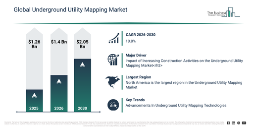
The size of the underground utility mapping market has experienced rapid growth in recent years. This market is projected to expand from $1.26 billion in 2025 to $1.4 billion in 2026, achieving a compound annual growth rate (CAGR) of 11.1%. The expansion witnessed in the historical period can be ascribed to the broadening of urban infrastructure projects, escalating underground utility congestion, a rise in incidents of excavation-related utility damage, the integration of geophysical surveying methods, and an increase in infrastructure maintenance activities.
The underground utility mapping market size is projected to experience rapid expansion in the coming years. It is forecast to reach $2.05 billion by 2030, exhibiting a compound annual growth rate (CAGR) of 10.0%. This growth during the forecast period can be attributed to factors such as increased investments in smart city infrastructure, a rising demand for real-time utility data access, the broadening of digital twin applications for infrastructure, a heightened focus on worker safety regulations, and the growing deployment of automated subsurface mapping tools. Significant trends anticipated for the forecast period include a greater adoption of ground penetration radar mapping solutions, the increasing integration of GIS-based utility mapping platforms, an expanded use of robotic crawlers for subsurface inspection, the development of 3D utility visualization technologies, and a stronger emphasis on damage prevention and safety compliance.
Get A Free Sample Report With In-Depth Market Insights:
Underground Utility Mapping Market Growth Backed By Core Demand Fundamentals
The expansion of construction endeavors is anticipated to fuel the future growth of the underground utility mapping market. Construction refers to the process of erecting or assembling various structures, infrastructure, or facilities according to predetermined plans and designs. The rise in construction activities can be attributed to elements such as increasing urbanization, population expansion, infrastructure development initiatives, and greater investment in real estate ventures. Precise mapping assists construction crews in pinpointing the exact location of subterranean utilities like water pipes, gas lines, and electrical cables. This vital information is crucial for averting accidental harm during excavation, ensuring site safety, and circumventing expensive repairs. For instance, in July 2025, a report from the US Census Bureau, a US-based government agency, indicated that educational construction reached a seasonally adjusted annual rate of $111.8 billion in May, marking a 0.2 percent (±2.1 percent) increase from the revised April estimate of $111.6 billion. Consequently, the uptick in construction activities is propelling the expansion of the underground utility mapping market.
Underground Utility Mapping Market Segments: Where Is Growth Concentrated?
The underground utility mapping market covered in this report is segmented –
1) By Component Type: Solutions, Services
2) By Technology: Electromagnetic (EM), Magnetic, Sonic Or Acoustic, Ground Penetration Radar, Live Line Detector, Robotic Crawler, Other Technologies
3) By Application: Positioning, Identification, Detection
4) By End-Use: Oil And Gas, Defense, Telecommunication, Electricity And Drainage, Railways, Other End Uses
Subsegments:
1) By Solutions: Geophysical Mapping Solutions, Gis-based Mapping Solutions, Ground Penetrating Radar (GPR) Solutions, Electromagnetic Induction Solutions, 3D Mapping And Visualization Tools
2) By Services: Surveying And Mapping Services, Data Collection And Analysis Services, Consultation And Planning Services, Installation And Integration Services, Support And Maintenance Services
Underground Utility Mapping Market Growth Trends Reshaping The Competitive Landscape
Leading companies in the underground utility mapping market are actively developing advanced products that incorporate sophisticated technologies, such as real-time kinematics (RTK) technology, to achieve a competitive advantage. Real-time kinematics (RTK) technology is an advanced GPS correction method that enhances satellite data to provide sub-inch accuracy instantaneously. For illustration, in November 2023, Radiodetection, a UK-based firm specializing in the design, manufacturing, and sale of equipment for locating and maintaining buried pipes and cables, introduced the RD8200SG, a high-precision multifunction cable and pipe locator. This product integrates real-time kinematics (RTK) technology, which not only elevates the accuracy of underground utility mapping but also optimizes operational processes by delivering immediate, actionable information. The RD8200SG is built to operate effectively in both congested urban settings and demanding rural landscapes, ensuring precision and dependability in utility detection and mapping. The incorporation of RTK technology significantly boosts precision and contributes to a safer working environment by decreasing the chances of accidental utility strikes.
Underground Utility Mapping Market Leading Players And Competitive Positioning
Major companies operating in the underground utility mapping market report areMinnesota Mining and Manufacturing Company (3M), Hexagon AB, Trimble Inc., Topcon Corporation, Leica Geosystems AG, Bentley Systems Incorporated, Ground Penetrating Radar Systems LLC, Plowman Craven Limited, IDS GeoRadar s.r.l., AirX Utility Surveyors Inc., Geophysical Survey Systems Inc., Guideline Geo AB, Vivax Metrotech Corporation, Sensors & Software Inc., Radiodetection Ltd., Diversified Underground Inc., Landscope Engineering Ltd., Maverick Inspection Ltd., ProStar GeoCorp. Inc., US Radar Inc., multiVIEW Locates Inc., Geotec Surveys Limited, Subsurface Utility Imaging LLC, Stoner & Associates Inc., Geospatial Corporation, Asian Contec Ltd (Stanlay), Red Laser Scanning Ltd., GeoModel Inc.
View The Full Underground Utility Mapping Market Report:
Underground Utility Mapping Market Regional Distribution: Which Areas Power Market Growth?
North America was the largest region in the underground utility mapping market in 2025.Asia-Pacific is expected to be the fastest-growing region in the forecast period. The regions covered in the underground utility mapping market report are Asia-Pacific, South East Asia, Western Europe, Eastern Europe, North America, South America, Middle East, Africa.
Reach Out To Our Team:
The Business Research Company: https://www.thebusinessresearchcompany.com/
Americas: +1 310-496-7795
Asia: +44 7882 955267 & +91 8897263534
Europe: +44 7882 955267
Email us at: marketing@tbrc.info
Follow us on:
LinkedIn: https://in.linkedin.com/company/the-business-research-company
YouTube: https://www.youtube.com/channel/UC24_fI0rV8cR5DxlCpgmyFQ
Global Market Model: https://www.thebusinessresearchcompany.com/global-market-model

Wasay has over a decade of experience in market research, data modelling, and analytics, with prior experience at GlobalData and Decision Tree Consulting Services. At The Business Research Company , he leads research operations across syndicated studies, customized consulting engagements, and the Global Market Model platform. His professional experience includes supporting organizations such as Boston Consulting Group, KPMG, and Ernst & Young. Wasay holds a degree in Electronics and Communications Engineering, postgraduate management qualifications from International Management Institute Belgium and Indian School of Business and Entrepreneurship, and completed the Integrated Program in Business Analytics from Indian Institute of Management Indore.