The Business Research Company’s 2026 market reports combine market attractiveness scoring, total addressable market sizing, company benchmarking matrices, interactive Excel dashboards, deeper supply chain intelligence, emerging startup tracking, and granular product-level insights to deliver research that is more actionable and strategically valuable.
Remote Sensing Services Market Value Projected To Grow At A 16.8% Compound Annual Growth Rate Through 2030
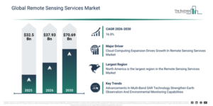
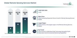
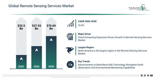
The remote sensing services market size has seen rapid growth in recent years. This market is projected to expand from $32.5 billion in 2025 to $37.93 billion in 2026, exhibiting a compound annual growth rate (CAGR) of 16.7%. The market’s historical expansion can be attributed to several factors, including the increasing demand for geospatial intelligence, the expansion of satellite imaging programs, the growth in defense and surveillance applications, the rising use of GIS-based planning tools, and the availability of commercial satellite data.
The remote sensing services market is expected to undergo significant expansion in the coming years, with its size projected to reach $70.69 billion by 2030, exhibiting a compound annual growth rate (CAGR) of 16.8%. This projected growth during the forecast period is attributed to several factors, including the increasing adoption of real-time earth observation services, a rising demand for climate and environmental monitoring, the expansion of smart infrastructure planning, the growing use of predictive geospatial analytics, and increased integration with digital twin platforms. Prominent trends anticipated in this period include the rising application of AI-based image interpretation, increased adoption of satellite and UAV data services, a growing demand for high-resolution geospatial analytics, the expansion of cloud-based remote sensing platforms, and an enhanced focus on real-time environmental monitoring.
Evaluate The Remote Sensing Services Market Report Before You Buy With A Free Sample:
Remote Sensing Services Market Growth Driver Analysis For The 2026–2030 Forecast Period
The anticipated expansion of the cloud computing market is set to drive the advancement of the remote sensing services market in the future. Cloud computing encompasses the provision of various computing services, including infrastructure elements like servers, storage, databases, networking, software, analytics, and intelligence. Such services facilitate accelerated innovation, adaptable resources, and the achievement of economies of scale. Furthermore, cloud services play a crucial role in speeding up technology transfer within remote sensing by enhancing the sharing of applications. They also enable a more direct connection between remote sensing scientists and end-users. As an illustration, data from April 2024, released by Eurostat, a Luxembourg-based statistical office of the European Union, revealed that 45% of businesses in the European Union acquired cloud computing services. Adoption rates were particularly high among large enterprises, reaching 78%, while 44% of small and medium-sized enterprises also utilized these services. Consequently, the expansion of cloud computing is poised to significantly boost the remote sensing services market’s development.
Remote Sensing Services Market Segmentation Breakdown: Primary And Secondary Categories
The remote sensing services market covered in this report is segmented –
1) By Type: Aerial Photography And Remote Sensing, Data Acquisition And Analytics
2) By Platform: Defense, Media And Entertainment, Homeland Security Agencies, Agriculture, Energy And Power, Scientific Research, Weather Forecasting, Other Platforms
3) By Resolution Segments: Spatial, Spectral, Temporal, Radiometric
Subsegments:
1) By Aerial Photography And Remote Sensing: Aerial Photography, Satellite Imagery, Unmanned Aerial Vehicles (UAVs) Or Drones
2) By Data Acquisition And Analytics: Data Collection, Data Processing, Data Analysis And Interpretation, Geographic Information Systems (GIS) Services
Remote Sensing Services Market Industry Trends: New Developments From Leading Companies
Major companies engaged in the remote sensing services market are prioritizing the development of sophisticated solutions, such as integrated multi-band synthetic aperture radar (SAR), to elevate Earth observation capabilities, improve environmental oversight, and facilitate precise analysis of global ecosystems. Integrated multi-band SAR is a technology that integrates multiple radar frequency bands, including L-band and S-band, to achieve deeper penetration through vegetation, enable higher-resolution mapping of surface deformation, and enhance the monitoring of cryospheric changes. For example, in November 2023, the Indian Space Research Organisation (ISRO), an India-based national space agency, and the National Aeronautics and Space Administration (NASA), a US-based government agency, collectively declared that the NASA-ISRO Synthetic Aperture Radar (NISAR) satellite was set to launch aboard ISRO’s GSLV. This satellite, outfitted with an integrated L- and S-band SAR system, has its radar payloads currently undergoing testing at ISRO’s URSC facility in Bangalore with assistance from NASA’s Jet Propulsion Laboratory. The data provided by NISAR will be vital for investigating land ecosystems, solid Earth deformation, mountain and polar cryosphere dynamics, sea ice, and coastal ocean processes across regional and global scales.
Who Are The Top Competitors In The Remote Sensing Services Market?
Major companies operating in the remote sensing services market are Antrix Corporation Limited; CyberSWIFT Infotech Pvt. Ltd.; DigitalGlobe Inc.; Ekofastba SL; Geo Sense Sdn. Bhd.; Lockheed Martin Corporation; Mallon Technology Ltd.; Remote Sensing Solutions GmbH; Satellite Imaging Corporation; Spectir LLC; Terra Remote Sensing Inc.; The Airborne Sensing Corporation; The Sanborn Map Company; Ball Corporation; General Dynamics Mission Systems Inc.; Hexagon AB; Space Exploration Technologies Corporation; Stantec Inc.; The Boeing Company; Airbus Defence and Space Ltd.; BlackSky Global LLC; Blue Marble Geographics Inc.; Earth-I Ltd.; Ecometrica Ltd.; EOMAP GmbH & Co.KG; Environmental Systems Research Institute Inc.; European Space Imaging GmbH; GeoOptics Inc.; Geosys Enterprise Solutions Private Limited; L3Harris Geospatial Solutions Inc.; ICEYE Ltd.; ImageSat International Ltd.; Intermap Technologies Corp.
Access The Remote Sensing Services Market Report For Complete Segment-Level Analysis:
Which Region Leads The Remote Sensing Services Market, And Which Regions Are Covered?
North America was the largest region in the remote sensing services market in 2025. The regions covered in the remote sensing services market report are Asia-Pacific, South East Asia, Western Europe, Eastern Europe, North America, South America, Middle East, Africa.
Reach Out To Our Team:
The Business Research Company: https://www.thebusinessresearchcompany.com/
Americas: +1 310-496-7795
Asia: +44 7882 955267 & +91 8897263534
Europe: +44 7882 955267
Email us at: marketing@tbrc.info
Follow us on:
LinkedIn: https://in.linkedin.com/company/the-business-research-company
YouTube: https://www.youtube.com/channel/UC24_fI0rV8cR5DxlCpgmyFQ
Global Market Model: https://www.thebusinessresearchcompany.com/global-market-model

Wasay has over a decade of experience in market research, data modelling, and analytics, with prior experience at GlobalData and Decision Tree Consulting Services. At The Business Research Company , he leads research operations across syndicated studies, customized consulting engagements, and the Global Market Model platform. His professional experience includes supporting organizations such as Boston Consulting Group, KPMG, and Ernst & Young. Wasay holds a degree in Electronics and Communications Engineering, postgraduate management qualifications from International Management Institute Belgium and Indian School of Business and Entrepreneurship, and completed the Integrated Program in Business Analytics from Indian Institute of Management Indore.