
Featuring market attractiveness scoring, total addressable market sizing, company benchmarking matrices, interactive Excel dashboards, deeper supply chain intelligence, emerging startup tracking, and granular product-level insights, The Business Research Company’s 2026 market reports are built to deliver research that is both more actionable and more strategically valuable.
Remote Sensing Satellite Market CAGR Outlook And Future Development
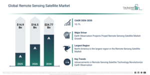
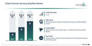
The remote sensing satellite market has experienced significant growth in recent years. This market is projected to expand from $14.9 billion in 2025 to $16.5 billion in 2026, achieving a compound annual growth rate (CAGR) of 10.8%. Historically, this expansion can be attributed to several factors including an increasing demand for earth observation and environmental monitoring, technological advancements in multispectral and hyperspectral sensors, government investments in space programs and satellite launches, the rising adoption of lidar and electromagnetic sensors for detailed mapping, and the growth in agricultural and forestry monitoring applications utilizing remote sensing data.
The remote sensing satellite market is projected to experience substantial expansion in the coming years. This market is forecast to reach $24.77 billion by 2030, exhibiting a compound annual growth rate (CAGR) of 10.7%. Factors contributing to this growth during the forecast period include the proliferation of high-resolution and constellation remote sensing satellites, the incorporation of AI and machine learning for analyzing data and creating predictive models, a rising commercial need for geospatial intelligence and analytics, the creation of economical small and medium-sized satellites for remote sensing, and the increasing application of these satellites for tracking climate change and managing disasters. Key trends anticipated during this period encompass the reduction in size of satellite sensors, a growing demand for high-resolution imagery, an increase in government-led space initiatives, the growth of private space enterprises, and the incorporation of multiple sensor payloads.
Get A Free Sample Report With In-Depth Market Insights:
Remote Sensing Satellite Market Growth Catalysts And Demand Drivers
The anticipated increase in earth observation projects is set to propel the remote sensing satellite market going forward. Earth observation projects refer to initiatives or programs that utilize various technologies, including satellites, aircraft, or ground-based sensors, to collect data and information regarding Earth’s surface, atmosphere, and oceans. Remote sensing satellites are instrumental in monitoring and assessing natural disasters such as hurricanes, floods, wildfires, earthquakes, and tsunamis. They provide real-time or near-real-time imagery and data, which aids in disaster response, evacuation planning, damage assessment, and recovery efforts. For instance, in January 2024, according to the Science of The Total Environment, a Netherland-based Peer-reviewed journal, the number of Earth Observation (EO) satellites has grown exponentially over the past decade, reaching a total of 1,193 as of January 2023. Therefore, the rise in earth observation projects is driving the growth of the remote sensing satellite market.
Remote Sensing Satellite Market Segment Landscape: Which Areas Lead Development?
The remote sensing satellite market covered in this report is segmented –
1) By Type: Space-Based Radars, Space-Based Electro-Optical And Infrared (EO/IR)
2) By Payload: Less Than 500 Kg, 500 Kg To 1,000 Kg, Above 1,000 Kg
3) By Application: Agricultural And Soil Studies, Natural Resources Monitoring And Conservation, Cartography, Geology And Mineral Resources Mapping, Meteorology And Oceanic Studies, Other Applications
4) By End Use: Civil, Military, Government, Others End Uses
Subsegments:
1) By Space-Based Radars: Synthetic Aperture Radar (SAR), Ground Penetrating Radar (GPR), Weather and Environmental Monitoring Radars, Earth Observation and Surveillance Radars
2) By Space-Based Electro-Optical and Infrared (EO/IR): Electro-Optical Imaging Satellites, Infrared Sensing Satellites, Thermal and Multispectral Imaging Satellites
Remote Sensing Satellite Market Trends Shaping Long-Term Demand
Key players within the remote sensing satellite market are increasingly concentrating on developing innovative products, such as earth observation nanosatellites, to secure a competitive advantage in the sector. Earth observation nanosatellites are compact satellites specifically engineered to monitor and gather data concerning Earth’s surface, atmosphere, and oceans. As an illustration, in June 2023, Azista BST Aerospace Pvt. Ltd., an aerospace firm based in India, unveiled the ABA First Runner (AFR), a remote sensing satellite crafted to capture panchromatic images with a 5-meter resolution and a 70-kilometer swath. Weighing 80 kg, this satellite is intended to provide remote sensing data to clients primarily in Southeast Asia and India, emphasizing strategic and agricultural areas. The collected data will serve applications in agriculture, forestry, water management, mining, maritime operations, and defense. These technological enhancements improve satellite performance, allowing for more precise and extensive data collection, consequently boosting its utility across numerous industries and applications.
Remote Sensing Satellite Market Industry Leaders And Competitive Landscape
Major companies operating in the remote sensing satellite market are Raytheon Technologies Corporation, The Boeing Company, Lockheed Martin Corporation, Airbus SE, Northrop Grumman, Mitsubishi Electric Corporation, Thales Group, L3Harris Technologies Inc., BALL CORPORATION, Hexagon AB, General Dynamics Mission Systems Inc., Maxar Technologies Inc., Environmental Systems Research Institute Inc.(Esri), AABSyS IT Pvt. Ltd, Planet Labs Inc., Orbital Insight, BlackSky Global LLC, Satellite Imaging Corporation, Mallon Technology, Antrix Corporation, Geo Sense, Remote Sensing Solutions GmbH, ImageSat International N.V.
View The Full Remote Sensing Satellite Market Report:
Remote Sensing Satellite Market Regional Analysis And Leading Geography
North America was the largest region in the remote sensing satellite market in 2025. Asia-Pacific is expected to be the fastest-growing region in the forecast period. The regions covered in the remote sensing satellite market report are Asia-Pacific, South East Asia, Western Europe, Eastern Europe, North America, South America, Middle East, Africa.
Reach Out To Our Team:
The Business Research Company: https://www.thebusinessresearchcompany.com/
Americas: +1 310-496-7795
Asia: +44 7882 955267 & +91 8897263534
Europe: +44 7882 955267
Email us at: marketing@tbrc.info
Follow us on:
LinkedIn: https://in.linkedin.com/company/the-business-research-company
YouTube: https://www.youtube.com/channel/UC24_fI0rV8cR5DxlCpgmyFQ
Global Market Model: https://www.thebusinessresearchcompany.com/global-market-model

Wasay has over a decade of experience in market research, data modelling, and analytics, with prior experience at GlobalData and Decision Tree Consulting Services. At The Business Research Company , he leads research operations across syndicated studies, customized consulting engagements, and the Global Market Model platform. His professional experience includes supporting organizations such as Boston Consulting Group, KPMG, and Ernst & Young. Wasay holds a degree in Electronics and Communications Engineering, postgraduate management qualifications from International Management Institute Belgium and Indian School of Business and Entrepreneurship, and completed the Integrated Program in Business Analytics from Indian Institute of Management Indore.