Featuring market attractiveness scoring, total addressable market sizing, company benchmarking matrices, interactive Excel dashboards, deeper supply chain intelligence, emerging startup tracking, and granular product-level insights, The Business Research Company’s 2026 market reports are built to deliver research that is both more actionable and more strategically valuable.
Drone Geospatial Analytics Market CAGR Outlook And Future Development
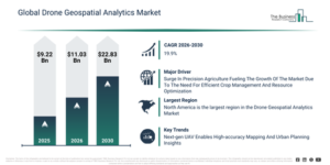
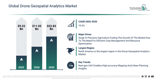
The drone geospatial analytics market has observed substantial expansion in recent years. Its size is expected to grow from $9.22 billion in 2025 to $11.03 billion in 2026, demonstrating a compound annual growth rate (CAGR) of 19.7%. The expansion witnessed in the past can be ascribed to several factors, such as the increased adoption of drones for surveying and mapping, a growing need for geospatial data analytics, enhancements in imaging sensors and cameras, the rise in infrastructure and urban planning initiatives, and government programs aimed at smart city development.
The drone geospatial analytics market size is anticipated to experience substantial growth over the next few years. It is projected to expand to $22.83 billion in 2030, achieving a compound annual growth rate (CAGR) of 19.9%. This expansion during the forecast period is attributable to the increasing deployment of drone services in agriculture and energy sectors, the adoption of AI-driven geospatial analytics, the integration of cloud-based mapping and visualization platforms, a growing utilization of multispectral and thermal imaging sensors, and an increase in disaster management and emergency response applications. Notable trends for the forecast period include advanced drone imaging analytics, the integration of GIS and remote sensing, real-time spatial data monitoring, customized mapping and modeling services, and drone-based environmental and infrastructure assessment.
Get A Free Sample Report With In-Depth Market Insights:
Drone Geospatial Analytics Market Growth Momentum: What Factors Are Shaping Demand?
The increasing need for precision agriculture is anticipated to boost the expansion of the drone geospatial analytics market in the foreseeable future. Precision agriculture involves leveraging technology and data-driven tools to refine farming practices, enhance crop yields, and improve resource efficiency. This growing demand for precision agriculture is motivated by the necessity to efficiently increase crop yields through the precise application of resources such as water and fertilizers, utilizing data and technology. Drone geospatial analytics is consequently fueling the rising demand for precision agriculture platforms by equipping farmers with accurate aerial data to optimize crop management and resource usage. For instance, in December 2024, information from the ProAg Crop Insurance Company, a US-based insurance firm, revealed that 68% of large crop farms earning over $1 million annually and 27% of all farms had adopted precision agriculture technology. Therefore, the escalating demand for precision agriculture is expected to drive the growth of the drone geospatial analytics market.
Drone Geospatial Analytics Market Segment Analysis Spotlighting Growth Areas
The drone geospatial analytics market covered in this report is segmented –
1) By Component: Software, Hardware, Services
2) By Deployment Mode: On-Premises, Cloud
3) By Application: Surveying And Mapping, Monitoring And Inspection, Volume Measurement, Disaster And Emergency Management
4) By End-User: Government, Defense, Agriculture, Energy And Utilities, Transportation And Logistics, Real Estate, Other End-User
Subsegments:
1) By Software: Data Processing Software, Mapping And Visualization Software, Image Analysis Software, Terrain Modeling Software, Workflow Management Software
2) By Hardware: Sensors And Cameras, Light Detection And Ranging Sensors, Multispectral Imaging Sensors, Thermal Imaging Sensors, Global Navigation Satellite Systems Equipment, Onboard Data Storage Devices
3) By Services: Data Acquisition Services, Data Processing And Interpretation Services, Mapping And Surveying Services, Consulting And Advisory Services, Maintenance And Support Services
Drone Geospatial Analytics Market Trends Redefining Industry Growth
Leading companies in the drone geospatial analytics market are concentrating on advancements within smart city and urban planning initiatives, leveraging geospatial intelligence to boost mapping accuracy and deliver actionable insights across industries like agriculture, defense, urban planning, and environmental monitoring. Geospatial intelligence refers to the examination of geographic and spatial data to facilitate decision-making and gain practical understanding. For example, in August 2025, ideaForge Technology Limited, an India-based UAV technology provider, launched the Q6V2 GEO UAV, a versatile drone designed to provide comprehensive geospatial analytics. It features modular payload capabilities, extended flight endurance, and autonomous navigation, enabling precise topographical mapping, urban planning surveys, and infrastructure inspection. Its unique attributes include real-time data transmission, high-accuracy LiDAR and photogrammetry integration, and ruggedized construction for operation in challenging environments, making it a cost-effective and agile solution for enterprises needing reliable geospatial intelligence.
Drone Geospatial Analytics Market Competitive Landscape: Who Leads The Industry?
Major companies operating in the drone geospatial analytics market are SZ DJI Technology Co. Ltd., Trimble Inc., Environmental Systems Research Institute Inc., Bentley Systems Incorporated, Terra Drone Corporation, Skydio Inc., DroneDeploy Inc., Wingtra AG, Delair SAS, vHive Tech Ltd., Kespry, Raptor Maps, ideaForge Technology Limited, Datumate Ltd., Skycatch Inc., SimActive Inc., Virtual Surveyor NV, Hammer Missions Ltd, Drone Harmony AG, Picterra SA, and Pix4D.
View The Full Drone Geospatial Analytics Market Report:
Drone Geospatial Analytics Market Geographic Landscape: Which Region Leads Industry Growth?
North America was the largest region in the drone geospatial analytics market in 2025. Asia-Pacific is expected to be the fastest-growing region in the forecast period. The regions covered in the drone geospatial analytics market report are Asia-Pacific, South East Asia, Western Europe, Eastern Europe, North America, South America, Middle East, Africa.
Reach Out To Our Team:
The Business Research Company: https://www.thebusinessresearchcompany.com/
Americas: +1 310-496-7795
Asia: +44 7882 955267 & +91 8897263534
Europe: +44 7882 955267
Email us at: marketing@tbrc.info
Follow us on:
LinkedIn: https://in.linkedin.com/company/the-business-research-company
YouTube: https://www.youtube.com/channel/UC24_fI0rV8cR5DxlCpgmyFQ
Global Market Model: https://www.thebusinessresearchcompany.com/global-market-model

Wasay has over a decade of experience in market research, data modelling, and analytics, with prior experience at GlobalData and Decision Tree Consulting Services. At The Business Research Company , he leads research operations across syndicated studies, customized consulting engagements, and the Global Market Model platform. His professional experience includes supporting organizations such as Boston Consulting Group, KPMG, and Ernst & Young. Wasay holds a degree in Electronics and Communications Engineering, postgraduate management qualifications from International Management Institute Belgium and Indian School of Business and Entrepreneurship, and completed the Integrated Program in Business Analytics from Indian Institute of Management Indore.