With a focus on actionable insights and strategic value, The Business Research Company’s 2026 market reports include market attractiveness scoring, total addressable market sizing, company benchmarking matrices, interactive Excel dashboards, deeper supply chain intelligence, emerging startup tracking, and granular product-level insights.
Defense Geospatial Market Size Outlook: A $218.23 Billion Market By 2030, Growing At 10.2% Annually
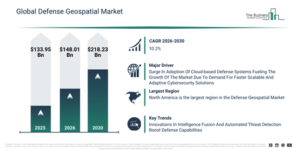
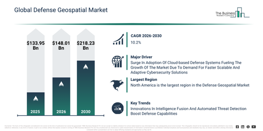
The defense geospatial market has recently seen substantial growth. It is expected to grow from $133.95 billion in 2025 to $148.01 billion in 2026, exhibiting a compound annual growth rate (CAGR) of 10.5%. This historical expansion can be attributed to various factors such as the increasing deployment of GIS and satellite imagery for battlefield awareness and mission planning, the spread of remote sensing technologies aiding reconnaissance and threat detection, the development of digital terrain elevation data improving targeting and navigation accuracy, the adoption of mapping tools and dashboards for real-time operational coordination, and the growing need for force tracking and blue force monitoring systems in modern military contexts.
The defense geospatial market is projected to experience substantial expansion in the coming years, reaching $218.23 billion by 2030, driven by a compound annual growth rate (CAGR) of 10.2%. This anticipated increase is primarily due to the heightened incorporation of AI and machine learning for automated geospatial intelligence analysis, the escalating requirement for high-resolution and continuous geospatial data from advanced satellite constellations, the broader implementation of real-time 3D mapping and simulation features for mission rehearsal, the increased embrace of cloud-based geospatial platforms facilitating quicker data exchange among defense units, and the creation of multi-source fused geospatial intelligence systems supporting intricate joint operations. Key developments during this period will encompass the surging need for real-time terrain intelligence, the wider integration of high-resolution satellite imagery, a greater uptake of automated force tracking instruments, the growing deployment of multi-layer urban warfare mapping, and the merging of geospatial dashboards for mission command.
Make Data-Driven Decisions With A Free Defense Geospatial Market Sample Report:
Key Demand Driver Expected To Lift Defense Geospatial Market Revenue
The growing integration of cloud-based defense systems is expected to fuel the expansion of the defense geospatial market moving forward. These systems refer to military or defense operations and technologies that utilize cloud computing for data storage, processing, and communication. The increasing uptake of cloud-based defense systems is a response to the demand for faster, scalable, and more adaptive cybersecurity solutions. Cloud-based defense systems enable real-time mapping and analysis of threat environments, supporting quicker decision-making and efficient resource deployment through cloud-integrated spatial intelligence. For instance, in 2024, the Thales Group, a France-based aerospace company, indicated that cloud security is ranked as the second most critical security discipline (65%) and the leading emerging security concern (72%). Therefore, the increasing adoption of cloud-based defense systems is a key driver for the growth of the defense geospatial market.
Exploring The Defense Geospatial Market Through Its Key Segments
The defense geospatial market covered in this report is segmented –
1) By Type: Surface Analysis, Network Analysis, Geo Visualization
2) By Technology: Geographic Information Systems (GIS), Remote Sensing, Photogrammetry, Light Detection And Ranging (LIDAR), Point Cloud Processing
3) By Application: Intelligence, Surveillance, And Reconnaissance (ISR), Command And Control (C2), Logistics And Supply Chain Management, Mission Planning And Execution, Training And Simulation
4) By End-User: Defense Forces, Government Agencies, Commercial Entities, Utilities, Non-Governmental Organizations (NGOs)
Subsegments:
1) By Surface Analysis: Terrain Modeling, Elevation Mapping, Land Use Or Land Cover Analysis, Vegetation Analysis, Soil Analysis
2) By Network Analysis: Route Optimization, Connectivity Analysis, Logistics And Supply Chain Mapping, Infrastructure Network Analysis, Communication Network Planning
3) By Geo Visualization: 2D Mapping, 3D Mapping And Visualization, Real-time Data Visualization, Augmented Reality (AR) Visualization, Interactive Dashboards And Mapping Tools
New Trends Redefining Competition In The Defense Geospatial Market
Leading companies within the defense geospatial market are concentrating on advancements in geospatial technologies, such as multi-source intelligence fusion, to boost situational understanding, enhance decision-making accuracy, and enable quicker response times in complex operational settings. This multi-source intelligence fusion involves integrating data from various intelligence sources to generate a comprehensive and actionable operational overview. As an illustration, in February 2025, Edge Group, a UAE-based aerospace and defense firm, launched TACTICA, an advanced AI-powered geospatial intelligence platform designed to integrate diverse data sources for improved situational awareness. It harnesses cutting-edge AI, including the falcon large language model, to offer real-time operational insights that support decision-making in defense, security, and strategic areas. The platform incorporates collaborative mission planning features, facilitating seamless coordination among multiple agencies during operations, and also includes automated anomaly detection to swiftly identify threats within extensive geospatial data.
Defense Geospatial Market Competition: Key Players And Industry Participants
Major companies operating in the defense geospatial market are Raytheon Technologies Corporation, Lockheed Martin Corporation, Airbus Group, Northrop Grumman Corporation, Collins Aerospace, BAE Systems plc, Thales Group, L3Harris Technologies Inc., Leidos Holdings Inc., Hexagon AB, Edge Group, Trimble Inc., Environmental Systems Research Institute Inc., Bentley Systems Incorporated, NV5 Global Inc., Advent International Corporation, BlackSky Technology Inc., Orbital Insight Inc., TerraGo Technologies Inc., MapLarge Inc.
Get The Detailed Defense Geospatial Market Research Report Here:
Defense Geospatial Market Regional Overview: Largest Market And Global Coverage
North America was the largest region in the defense geospatial market in 2025. Asia-Pacific is expected to be the fastest-growing region in the forecast period. The regions covered in the defense geospatial market report are Asia-Pacific, South East Asia, Western Europe, Eastern Europe, North America, South America, Middle East, Africa.
Reach Out To Our Team:
The Business Research Company: https://www.thebusinessresearchcompany.com/
Americas: +1 310-496-7795
Asia: +44 7882 955267 & +91 8897263534
Europe: +44 7882 955267
Email us at: marketing@tbrc.info
Follow us on:
LinkedIn: https://in.linkedin.com/company/the-business-research-company
YouTube: https://www.youtube.com/channel/UC24_fI0rV8cR5DxlCpgmyFQ
Global Market Model: https://www.thebusinessresearchcompany.com/global-market-model

Wasay has over a decade of experience in market research, data modelling, and analytics, with prior experience at GlobalData and Decision Tree Consulting Services. At The Business Research Company , he leads research operations across syndicated studies, customized consulting engagements, and the Global Market Model platform. His professional experience includes supporting organizations such as Boston Consulting Group, KPMG, and Ernst & Young. Wasay holds a degree in Electronics and Communications Engineering, postgraduate management qualifications from International Management Institute Belgium and Indian School of Business and Entrepreneurship, and completed the Integrated Program in Business Analytics from Indian Institute of Management Indore.