
Delivering more actionable and strategically valuable research, The Business Research Company’s 2026 market reports feature market attractiveness analysis, total addressable market evaluation, company benchmarking matrices, interactive Excel dashboards, expanded supply chain intelligence, emerging startup coverage, and detailed product insights.
Commercial Satellite Imaging Market Expansion Outlook: What Revenue Opportunities Lie Ahead?
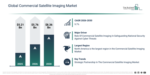
The commercial satellite imaging market has experienced rapid growth in its size during recent years. It is projected to grow from $5.21 billion in 2025 to $5.76 billion in 2026, at a compound annual growth rate (CAGR) of 10.7%. The historical expansion of this market can be attributed to several factors, including a heightened demand for high-resolution satellite imagery utilized in mapping and land-use analysis, an increase in the deployment of multispectral and hyperspectral imaging for environmental monitoring, the escalating adoption of satellite data for disaster response and assessment, the broadening of commercial satellite constellations which enhances imaging frequency, and the emergence of online mapping tools simplifying access to satellite imagery.
The commercial satellite imaging market is anticipated to undergo significant expansion in the coming years, reaching $8.36 billion by 2030, demonstrating a compound annual growth rate (CAGR) of 9.7%. This projected growth during the forecast period is fueled by an escalating requirement for real-time and ongoing earth observation data across diverse sectors, alongside the increasing deployment of smallsat and cubesat imaging constellations. Further contributions come from advancements in image analytics and AI-driven geospatial interpretation, the expanding use of satellite imaging for climate monitoring and sustainability initiatives, and the broadening of commercial services that provide integrated imaging, data layering, and bulk mapping solutions. Key trends expected over this period encompass a growing demand for ultra-high-resolution satellite imagery, the enhanced commercial application of multispectral and hyperspectral imaging, the widespread integration of satellite data for disaster prediction and response, the proliferation of cloud-based satellite analytics platforms, and a heightened need for satellite imaging in precision agriculture.
Download A Free Sample Report For Comprehensive Market Insights:
Commercial Satellite Imaging Market Opportunity Drivers: What Is Creating New Revenue Potential?
Growing concerns surrounding national security are expected to propel the commercial satellite imaging market forward. National security threats encompass any actions or events that risk the safety, stability, and security of a nation or its citizens, potentially originating from foreign governments, terrorist organizations, or cyber-attacks on government agencies. Satellite imaging data plays a vital role in preventing cyber-attacks on government agencies by offering valuable information for network monitoring, geolocation, early warning, response, and mitigation efforts. For instance, in November 2023, the 2023 ASD Cyber Threat Report by the Australian Signals Directorate, an Australia-based federal agency, indicated that ReportCyber documented nearly 94,000 reports of cybercrime during the 2022-23 financial year, marking a 23% increase over the previous financial year. Consequently, escalating national security concerns are driving the commercial satellite imaging market.
Commercial Satellite Imaging Market Segment Analysis And Revenue Opportunities
The commercial satellite imaging market covered in this report is segmented –
1) By Technology: Optical, Radar
2) By Application: Geospatial Data Acquisition And Mapping, Natural Resource Management, Surveillance And Security, Conservation And Research, Disaster Management, Defense And Intelligence
3) By End User: Government, Military And Defense, Forestry And Agriculture, Energy, Civil Engineering And Archaeology, Transportation And Logistics, Other End Users
Subsegments:
1) By Optical: High-Resolution Optical Imaging, Multispectral Imaging, Hyperspectral Imaging
2) By Radar: Synthetic Aperture Radar (SAR), Interferometric Synthetic Aperture Radar (InSAR)
#Commercial Satellite Imaging Market Trends Influencing Long-Term Demand
Leading entities within the commercial satellite imaging market are embracing a strategic partnership strategy to bolster the utilization of satellite imagery. Strategic partnerships signify a method where companies capitalize on each other’s strengths and resources to achieve mutual advantages and triumphs. For example, in April 2023, Axelspace, a Japan-based space startup focused on microsatellite technology, entered into a partnership with New Space Intelligence, a Japan-based firm that delivers satellite imagery analysis services. Through this collaboration, the companies intend to jointly propel the greater deployment of satellite data. Their combined initiatives will primarily concentrate on fostering the creation of new applications and extending services into international markets. This strategic alliance considerably enhances Axelspace’s footprint in innovative satellite image applications.
Commercial Satellite Imaging Market Leading Players Shaping Industry Direction
Major companies operating in the commercial satellite imaging market are Airbus SE, L3Harris Technologies Inc., Maxar Technologies Inc., DigitalGlobe Inc., Telespazio Spa, MDA Ltd., Planet Labs PBC, Radiant Solutions Inc., Spire Global Inc., Capella Space Inc., BlackSky Global LLC, GHGSat Inc., ImageSat International N.V. (iSi), UrtheCast Corp., Orbital Insight Inc., Descartes Labs Inc., Satellogic S.L.U., SpaceKnow Inc., Kleos Space S.A., European Space Imaging (EUSI) GmbH, Galileo Group Inc., Skylab Analytics, ICEYE Finland Oy, Satshots LLC, Predicio Analytics Inc.
Access The Complete Commercial Satellite Imaging Market Report:
Commercial Satellite Imaging Market Geographic Analysis: Where Is Demand Growing The Fastest?
North America was the largest region in the commercial satellite imaging market in 2025. Asia-Pacific is expected to be the fastest-growing region in the global commercial satellite imaging market report during the forecast period. The regions covered in the commercial satellite imaging market report are Asia-Pacific, South East Asia, Western Europe, Eastern Europe, North America, South America, Middle East, Africa.
Access a Customized Commercial Satellite Imaging Market Report for Deeper Competitive Insights
https://www.thebusinessresearchcompany.com/customise?id=9272&type=smp
The Business Research Company: https://www.thebusinessresearchcompany.com/
Americas: +1 310-496-7795
Asia: +44 7882 955267 & +91 8897263534
Europe: +44 7882 955267
Email us at: marketing@tbrc.info
Follow us on:
LinkedIn: https://in.linkedin.com/company/the-business-research-company
YouTube: https://www.youtube.com/channel/UC24_fI0rV8cR5DxlCpgmyFQ
Global Market Model: https://www.thebusinessresearchcompany.com/global-market-model

Wasay has over a decade of experience in market research, data modelling, and analytics, with prior experience at GlobalData and Decision Tree Consulting Services. At The Business Research Company , he leads research operations across syndicated studies, customized consulting engagements, and the Global Market Model platform. His professional experience includes supporting organizations such as Boston Consulting Group, KPMG, and Ernst & Young. Wasay holds a degree in Electronics and Communications Engineering, postgraduate management qualifications from International Management Institute Belgium and Indian School of Business and Entrepreneurship, and completed the Integrated Program in Business Analytics from Indian Institute of Management Indore.