With a focus on actionable insights and strategic value, The Business Research Company’s 2026 market reports include market attractiveness scoring, total addressable market sizing, company benchmarking matrices, interactive Excel dashboards, deeper supply chain intelligence, emerging startup tracking, and granular product-level insights.
#How Large Could The Drone-Assisted Urban Light Detection And Ranging (LiDAR) Mapping Market Become By 2030 At A 17.6% CAGR?#_x000D_
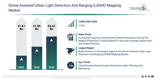
The drone-assisted urban light detection and ranging (lidar) mapping market has seen rapid expansion in recent years. This market is set to grow from $1.61 billion in 2025 to $1.89 billion in 2026, exhibiting a compound annual growth rate (CAGR) of 17.4%. Historically, the market’s expansion can be attributed to the rising adoption of UAV-assisted urban mapping, increased use of LiDAR for city planning, growth in high-precision 3D mapping projects, the expansion of real-time data processing, and increasing demand for terrain modeling and DEM generation._x000D_
_x000D_
The drone-assisted urban light detection and ranging (lidar) mapping market is projected to experience substantial expansion over the coming years. This market is forecast to reach $3.62 billion by 2030, exhibiting a compound annual growth rate (CAGR) of 17.6%. This growth during the forecast period is propelled by factors such as the increasing integration of AI-enabled analytics, the expansion of IoT-connected UAV networks, advancements in sustainable drone hardware, the rising adoption of cloud-based mapping platforms, and the development of sophisticated visualization and simulation tools. Key trends anticipated for the forecast period encompass the deployment of AI-enhanced lidar mapping systems, the integration of IoT-based drone monitoring networks, the expansion of 3D urban modeling and simulation platforms, the creation of real-time data processing and analytics solutions, and the implementation of sustainable and high-precision UAV hardware._x000D_
_x000D_
#Get A Free Drone-Assisted Urban Light Detection And Ranging (LiDAR) Mapping Market Sample With 2030 Forecast Insights:#_x000D_
_x000D_
#Drone-Assisted Urban Light Detection And Ranging (LiDAR) Mapping Market Outlook: Key Driver Supporting Long-Term Growth#_x000D_
The drone-assisted urban light detection and ranging (LiDAR) mapping market is projected to grow as the frequency and intensity of natural disasters continue to rise. These large-scale adverse events, such as floods, earthquakes, droughts, and storms, significantly impact urban environments. The escalation of natural disasters is primarily attributed to climate change, which intensifies extreme weather, alongside human activities like deforestation, pollution, and urbanization that worsen their effects. Drone-assisted urban light detection and ranging (LiDAR) mapping offers swift and highly accurate capabilities for damage assessment, terrain analysis, and rescue planning in the aftermath of these events, providing crucial data that accelerates emergency response and recovery efforts. For instance, according to the National Centers for Environmental Information (NCEI), a US-based government agency, the United States encountered 28 distinct weather and climate disasters in 2023, each inflicting damages exceeding $1 billion, with that number having climbed to 28 natural disasters. Thus, the increasing occurrence and severity of natural disasters are driving the expansion of the drone-assisted urban light detection and ranging (LiDAR) mapping market._x000D_
_x000D_
#Segmentation Of The Drone-Assisted Urban Light Detection And Ranging (LiDAR) Mapping Market: Key Categories Explained#_x000D_
The drone-assisted urban light detection and ranging (lidar) mapping market covered in this report is segmented – _x000D_
_x000D_
1) By Component: Hardware, Software, Services_x000D_
2) By Deployment Mode: On-Premises, Cloud_x000D_
3) By End-User: Government, Construction, Utilities, Transportation And Logistics, Other End-Users_x000D_
_x000D_
Subsegments:_x000D_
1) By Hardware: Light Detection And Ranging (LiDAR) Sensors, Cameras, Navigation Systems, Power Systems, Communication Systems, Control Systems_x000D_
2) By Software: Data Processing Software, Mapping Software, Analytics Software, Visualization Software, Simulation Software_x000D_
3) By Services: Deployment And Integration, Maintenance And Support, Training And Consulting, Managed Services, Data Acquisition Services_x000D_
_x000D_
#Drone-Assisted Urban Light Detection And Ranging (LiDAR) Mapping Market Evolving Trends: What Businesses Should Know#_x000D_
Leading firms within the drone-assisted urban light detection and ranging (LiDAR) mapping market are prioritizing the integration of advanced technologies, specifically cloud-based analytics, to boost data processing efficiency and provide quicker, more precise mapping results. Cloud-based analytics involves leveraging internet-connected remote servers and software for data storage, processing, and analysis. This significantly benefits drone-assisted LiDAR mapping by facilitating accelerated computation, seamless collaboration, and expandable storage solutions, thereby removing the need for local hardware. An illustrative example is Wingtra, a Switzerland-based manufacturing company, which introduced the WingtraRay in July 2025. This vertical takeoff and landing (VTOL) drone, tailored for survey professionals, incorporates WingtraGround for field data logging and WingtraCloud for cloud-based processing, allowing users to produce georeferenced orthomosaics, point clouds, and digital surface models with greater efficiency. This synergy of swift data acquisition and cloud analytics expedites urban LiDAR mapping workflows, minimizes dependence on physical hardware, and supports scalable, collaborative project execution. Consequently, it enhances decision-making across sectors like construction, environmental monitoring, and urban planning._x000D_
_x000D_
#Who Competes In The Drone-Assisted Urban Light Detection And Ranging (LiDAR) Mapping Market? Major Companies Listed#_x000D_
Major companies operating in the drone-assisted urban light detection and ranging (lidar) mapping market are SZ DJI Technology Co. Ltd., Trimble Inc., Leica Geosystems AG, Microdrones GmbH, Teledyne Optech Incorporated, Velodyne Lidar Inc., Ouster Inc., Wetland Studies and Solutions Inc., Innoviz Technologies Ltd., Emesent Pty Ltd., Delair SAS, Exyn Technologies Inc., FlyGuys Inc., Cepton Inc., RIEGL Laser Measurement Systems GmbH, YELLOWSCAN S.A.S., FlyPix AI GmbH, Phoenix LiDAR Systems Inc, Geodetics Inc., Fagerman Technologies Inc. _x000D_
_x000D_
#Read The Complete Drone-Assisted Urban Light Detection And Ranging (LiDAR) Mapping Market Forecast Report Through 2030:#_x000D_
_x000D_
#Drone-Assisted Urban Light Detection And Ranging (LiDAR) Mapping Market Regional Ranking: Which Geography Comes First?#_x000D_
North America was the largest region in the drone-assisted urban light detection and ranging (LiDAR) mapping market in 2025. Asia-Pacific is expected to be the fastest-growing region in the forecast period. The regions covered in the drone-assisted urban light detection and ranging (lidar) mapping market report are Asia-Pacific, South East Asia, Western Europe, Eastern Europe, North America, South America, Middle East, Africa._x000D_
_x000D_
#Reach Out To Our Team:#_x000D_
_x000D_
The Business Research Company: https://www.thebusinessresearchcompany.com/_x000D_
Americas: +1 310-496-7795_x000D_
Asia: +44 7882 955267 & +91 8897263534_x000D_
Europe: +44 7882 955267_x000D_
Email us at: marketing@tbrc.info_x000D_
_x000D_
#Follow us on:#_x000D_
_x000D_
LinkedIn: https://in.linkedin.com/company/the-business-research-company_x000D_
YouTube: https://www.youtube.com/channel/UC24_fI0rV8cR5DxlCpgmyFQ_x000D_
Global Market Model: https://www.thebusinessresearchcompany.com/global-market-model

Wasay has over a decade of experience in market research, data modelling, and analytics, with prior experience at GlobalData and Decision Tree Consulting Services. At The Business Research Company , he leads research operations across syndicated studies, customized consulting engagements, and the Global Market Model platform. His professional experience includes supporting organizations such as Boston Consulting Group, KPMG, and Ernst & Young. Wasay holds a degree in Electronics and Communications Engineering, postgraduate management qualifications from International Management Institute Belgium and Indian School of Business and Entrepreneurship, and completed the Integrated Program in Business Analytics from Indian Institute of Management Indore.