Delivering more actionable and strategically valuable research, The Business Research Company’s 2026 market reports feature market attractiveness analysis, total addressable market evaluation, company benchmarking matrices, interactive Excel dashboards, expanded supply chain intelligence, emerging startup coverage, and detailed product insights.
Aerial Imaging Market Size Forecast: How Large Could The Market Become By 2030?
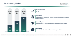
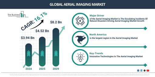
The aerial imaging market has experienced significant expansion recently. Projections indicate it will grow from $4.52 billion in 2025 to $5.24 billion in 2026, achieving a compound annual growth rate (CAGR) of 16.0%. The historical increase in market size is attributable to the increasing deployment of helicopters and UAVs for surveying, initial implementation in urban planning, the broadening of geospatial mapping, increased environmental monitoring, and early adoption in disaster management efforts.
The aerial imaging market is projected for substantial growth over the next few years. By 2030, this market is forecasted to reach $9.53 billion, demonstrating a compound annual growth rate (CAGR) of 16.1%. This expansion is attributed to several factors, including the rising implementation of multispectral and high-resolution imaging, the uptake of AI-driven aerial data analysis, developments in infrastructure and asset management, integration with IoT platforms, and the broadening use in agricultural and defense sectors. Significant trends expected during this period involve the incorporation of AI-enabled aerial imaging systems, the rollout of intelligent data processing platforms, the embrace of real-time image analysis, the proliferation of IoT-connected UAV imaging, and the execution of high-resolution multispectral imaging.
Download A Free Sample Report For Comprehensive Market Insights:
Aerial Imaging Market Demand Drivers: What Is Fueling Industry Growth?
The escalating frequency of natural disasters is predicted to stimulate the expansion of the aerial imaging market. Such events are sudden and catastrophic environmental changes, exemplified by hurricanes, tornadoes, or floods, predominantly caused by climate shifts, typically resulting in significant damage and numerous fatalities. Aerial imaging offers a way to implement rapid on-ground actions, considerably quicker than manual identification, assessment, and intervention, thus curbing further destruction and reducing overall response durations. Given the increasing incidents of natural disasters, there will be a heightened requirement for aerial imaging solutions to effectively handle these circumstances. As an illustration, in January 2024, the World Economic Forum, a Switzerland-based Tink Tank, reported that climate change might contribute to an additional 14.5 million deaths and $12.5 trillion in economic losses globally by 2050. Hence, the rising occurrences of natural disasters are indeed expected to drive the growth of the aerial imaging market.
Aerial Imaging Market Segmentation Trends And Revenue Drivers
The aerial imaging market covered in this report is segmented –
1) By Imaging Type: Vertical Imaging, Oblique Imaging
2) By Platform: Fixed Wing Aircraft, Helicopter, UAV And Drone, Other Platform
3) By Application: Geospatial Mapping, Infrastructure Planning, Asset Inventory Management, Environmental Monitoring, National And Urban Mapping, Surveillance And Monitoring, Disaster Management, Other Applications
4) By End-Use: Government, Energy, Military And Defense, Agriculture And Forestry, Archaeology And Civil Engineering, Oil And Gas, Other End-Users
Subsegments:
1) By Vertical Imaging: Conventional Vertical Imaging, High-resolution Vertical Imaging, Multispectral Vertical Imaging
2) By Oblique Imaging: Low Oblique Imaging, High Oblique Imaging, Multispectral Oblique Imaging
Aerial Imaging Market Trends: What Is Shaping Future Industry Growth?
Major companies within the aerial imaging market are creating advanced technologies, such as Atva, to deliver a more sustainable solution for aerial cargo transport. Atva is a adaptable and compact hybrid VTOL (Vertical Take Off and Landing) drone, engineered to redefine aerial cargo transport, mapping, and surveillance through its eVTOL technology. For instance, in October 2023, ePlane’s Amber Wings, an India-based developer of unmanned aerial vehicles, introduced Atva, a hybrid vertical takeoff and landing (VTOL) drone. Atva is considered a promising new development in drone technology, holding the potential to revolutionize several industries and generate a positive global impact. Additionally, Atva comes equipped with a range of sensors, including a high-resolution camera. This capability allows its utilization for mapping and surveillance applications, enabling the creation of detailed maps for extensive areas or the monitoring and surveying of specific regions of interest.
#Aerial Imaging Market Industry Leaders: Which Organizations Are Driving Competition?
Major companies operating in the aerial imaging market are Digital Aerial Solutions LLC, Airobotics Ltd., Cooper Aerial Surveys Co., EagleView Technologies Inc., Fugro N.V., SZ DJI Technology Co. Ltd., 3D Robotics Inc., Aeromao Inc., Aerovel Corporation, AgEagle Aerial Systems Inc., Airware Inc., Datumate Ltd., Delair Tech SAS, DroneDeploy Inc., Esri Inc., FLIR Systems Inc., Geomni Inc. (a Verisk Analytics business), Intel RealSense Group, MicaSense Inc., Nearmap Ltd., Optelos Corporation, Parrot Drones SAS, Phoenix LiDAR Systems Inc., Pix4D SA, PrecisionHawk Inc., Quantum Spatial Inc. (Aerometric Inc.), Quantum-Systems GmbH, senseFly SA (a Parrot company), sensemetrics Inc., SimActive Inc., Skydio Inc., SlantRange Inc., Trimble Inc., YellowScan SAS
Access The Complete Aerial Imaging Market Report:
Aerial Imaging Market Leading Geography: Which Region Generates The Most Revenue?
North America was the largest region in the aerial imaging market in 2025. The regions covered in the aerial imaging market report are Asia-Pacific, South East Asia, Western Europe, Eastern Europe, North America, South America, Middle East, Africa.
Get in touch with us:
The Business Research Company: https://www.thebusinessresearchcompany.com/
Americas: +1 310-496-7795
Asia: +44 7882 955267 & +91 8897263534
Europe: +44 7882 955267
Email us at: marketing@tbrc.info
Follow us on:
LinkedIn: https://in.linkedin.com/company/the-business-research-company
YouTube: https://www.youtube.com/channel/UC24_fI0rV8cR5DxlCpgmyFQ
Global Market Model: https://www.thebusinessresearchcompany.com/global-market-model

Wasay has over a decade of experience in market research, data modelling, and analytics, with prior experience at GlobalData and Decision Tree Consulting Services. At The Business Research Company , he leads research operations across syndicated studies, customized consulting engagements, and the Global Market Model platform. His professional experience includes supporting organizations such as Boston Consulting Group, KPMG, and Ernst & Young. Wasay holds a degree in Electronics and Communications Engineering, postgraduate management qualifications from International Management Institute Belgium and Indian School of Business and Entrepreneurship, and completed the Integrated Program in Business Analytics from Indian Institute of Management Indore.