Featuring market attractiveness scoring, total addressable market sizing, company benchmarking matrices, interactive Excel dashboards, deeper supply chain intelligence, emerging startup tracking, and granular product-level insights, The Business Research Company’s 2026 market reports are built to deliver research that is both more actionable and more strategically valuable.
Global Navigation Satellite System (GNSS) Imaging Market Size And Revenue Outlook Through 2030
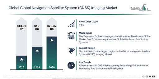
The global navigation satellite system (gnss) imaging market has experienced substantial growth in recent years. It is projected to expand from $13.93 billion in 2025 to $15 billion in 2026, demonstrating a compound annual growth rate (CAGR) of 7.7%. This historical expansion can be attributed to several factors, including the increased deployment of satellite navigation systems, the rising demand for digital mapping solutions, the broader scope of defense surveillance requirements, a surge in commercial GPS usage, and the development of early geospatial information systems.
The global navigation satellite system (gnss) imaging market is anticipated to experience substantial growth in the upcoming years. Its valuation is projected to escalate to $20.32 billion by 2030, demonstrating a compound annual growth rate (CAGR) of 7.9%. This expansion during the forecast period can be attributed to advancements in autonomous navigation systems, a surging demand for precision agriculture solutions, the increasing implementation of smart city infrastructure, the broadening applications of unmanned aerial systems, and the rising requirement for real-time location-based analytics. Noteworthy trends for this period encompass AI-driven geospatial intelligence processing, the adoption of real-time kinematic (rtk) for high precision positioning, the proliferation of unmanned aerial vehicle-based gnss imaging, the development of edge-enabled satellite data processing systems, and the integration of multi-source remote sensing data.
Get A Free Sample Report With In-Depth Market Insights:
Global Navigation Satellite System (GNSS) Imaging Market Expansion Drivers: What’s Shaping Future Growth?
The expansion of precision agriculture practices is anticipated to fuel the growth of the global navigation satellite system (GNSS) imaging market. These practices utilize advanced technologies such as global positioning systems, sensors, and data analytics to precisely manage crops and soil, optimizing inputs like water and fertilizers to enhance yield and sustainability. Advances in satellite-based positioning systems are a primary reason for this expansion, enabling farmers to accurately map fields and apply resources with high precision. Global navigation satellite system (GNSS) imaging further enhances precision agriculture by providing high-accuracy, real-time spatial and positioning data for optimized field mapping and resource management. For example, the Government Accountability Office reported that in 2023, 27% of farms and ranches in the U.S. had adopted precision agriculture practices for crop or livestock management. Consequently, the increasing adoption of precision agriculture is a key driver for the global navigation satellite system (GNSS) imaging market. The rising investments in smart city and infrastructure development are projected to stimulate the growth of the global navigation satellite system (GNSS) imaging market. These investments involve allocating financial resources to construct and upgrade urban systems like transportation, utilities, and digital networks to improve cities’ efficiency, sustainability, and quality of life. Rapid urbanization primarily drives these rising investments, increasing the demand for efficient urban services. Global Navigation Satellite System (GNSS) imaging benefits from these investments by facilitating the deployment of advanced geospatial monitoring systems, which enhance real-time mapping, asset tracking, and urban planning accuracy through high-precision satellite-based location data. For instance, according to Patent Professional Corporation, global IoT infrastructure spending for smart cities increased from $130 billion in 2023 to $200 billion by 2025, demonstrating an approximate 25% compound annual growth rate. Therefore, increasing investments in smart city and infrastructure development are propelling the global navigation satellite system (GNSS) imaging market.
Global Navigation Satellite System (GNSS) Imaging Market Segment Landscape And Growth Outlook
The global navigation satellite system (GNSS) imaging market covered in this report is segmented –
1) By Type: Satellite Based Positioning Imaging, Real Time Kinematic Imaging, Differential Global Navigation Satellite System Imaging, Precise Point Positioning Imaging, Global Navigation Satellite System Remote Sensing Imaging
2) By Deployment Platform: Airborne And Unmanned Aerial Vehicle Based, Spaceborne, Terrestrial Or Ground Based, Marine Based
3) By Application: Navigation And Mapping, Land Surveying, Agriculture Monitoring, Disaster Management, Transportation Tracking, Geospatial Data Services, Infrastructure Monitoring, Defense And Surveillance
4) By End User Industry: Government And Defense, Agriculture And Forestry, Transportation And Logistics, Environmental And Research Organizations, Infrastructure And Construction Companies, Telecommunications And Technology Companies
Subsegments:
1) By Satellite Based Positioning Imaging: Low Earth Orbit Satellite Imaging, Medium Earth Orbit Satellite Imaging, Geostationary Orbit Satellite Imaging, Geosynchronous Orbit Satellite Imaging
2) By Real Time Kinematic Imaging: Network Real Time Kinematic Imaging, Standalone Real Time Kinematic Imaging, Mobile Real Time Kinematic Imaging, Base Station Real Time Kinematic Imaging
3) By Differential Global Navigation Satellite System Imaging: Code Based Differential Imaging, Carrier Phase Based Differential Imaging, Network Differential Imaging, Mobile Differential Imaging
4) By Precise Point Positioning Imaging: Post Processed Precise Point Positioning Imaging, Real Time Precise Point Positioning Imaging, Network Assisted Precise Point Positioning Imaging, Standalone Precise Point Positioning Imaging
5) By Global Navigation Satellite System Remote Sensing Imaging: Airborne Remote Sensing Imaging, Satellite Remote Sensing Imaging, Ground Based Remote Sensing Imaging, Unmanned Aerial Vehicle Remote Sensing Imaging
Global Navigation Satellite System (GNSS) Imaging Market Strategic Trends: What Defines The Next Growth Phase?
Major organizations operating in the global navigation satellite system (GNSS) imaging market are prioritizing the development of advanced satellite-based solutions, such as GNSS reflectometry missions, aimed at improving environmental monitoring, enhancing water resource management, and supporting climate research. GNSS reflectometry describes a remote sensing technique that utilizes reflected signals from navigation satellites to measure surface characteristics, including soil moisture, water bodies, and ice conditions. For example, in November 2025, the European Space Agency, a France-based space agency, initiated the HydroGNSS mission. This satellite project is designed to map and monitor critical hydrological variables by using GNSS signals reflected from Earth’s surface. The mission intends to provide essential data on soil moisture, inundation, freeze–thaw states, and above-ground biomass, thereby enabling better flood prediction, drought monitoring, and sustainable water resource management, while also advancing the application of GNSS imaging technologies in Earth observation.
Global Navigation Satellite System (GNSS) Imaging Market Competitive Landscape: Who Leads The Industry?
Major companies operating in the global navigation satellite system (gnss) imaging market are Hexagon AB; Garmin Ltd.; Trimble Inc.; Fugro; CHC Navigation (CHCNAV); Advanced Navigation; HawkEye 360 Inc.; Furuno Electric Co. Ltd.; Emesent; Locosys Technology Inc.; ComNav Technology Ltd.; RIEGL Laser Measurement Systems; SBG Systems S.A.S.; EOS Positioning Systems Inc.; Tersus GNSS Inc.; Locata Corporation Pty Ltd.; Fixposition; TrustPoint Inc.; BDStar Navigation Co. Ltd.; NVS Technologies AG (nvs-gnss.com)
View The Full Global Navigation Satellite System (GNSS) Imaging Market Report:
Global Navigation Satellite System (GNSS) Imaging Market Geographic Landscape: Which Region Dominates Industry Growth?
North America was the largest region in the global navigation satellite system (GNSS) imaging market in 2025. Asia-Pacific is expected to be the fastest-growing region in the forecast period. The regions covered in the global navigation satellite system (gnss) imaging market report are Asia-Pacific, South East Asia, Western Europe, Eastern Europe, North America, South America, Middle East, Africa.
Reach Out To Our Team:
The Business Research Company: https://www.thebusinessresearchcompany.com/
Americas: +1 310-496-7795
Asia: +44 7882 955267 & +91 8897263534
Europe: +44 7882 955267
Email us at: marketing@tbrc.info
Follow us on:
LinkedIn: https://in.linkedin.com/company/the-business-research-company
YouTube: https://www.youtube.com/channel/UC24_fI0rV8cR5DxlCpgmyFQ
Global Market Model: https://www.thebusinessresearchcompany.com/global-market-model

Wasay has over a decade of experience in market research, data modelling, and analytics, with prior experience at GlobalData and Decision Tree Consulting Services. At The Business Research Company , he leads research operations across syndicated studies, customized consulting engagements, and the Global Market Model platform. His professional experience includes supporting organizations such as Boston Consulting Group, KPMG, and Ernst & Young. Wasay holds a degree in Electronics and Communications Engineering, postgraduate management qualifications from International Management Institute Belgium and Indian School of Business and Entrepreneurship, and completed the Integrated Program in Business Analytics from Indian Institute of Management Indore.