
Built to provide research that’s more actionable and strategically valuable, The Business Research Company’s 2026 market reports include market attractiveness analysis, total addressable market sizing, company benchmarking matrices, interactive Excel dashboards, broader supply chain intelligence, emerging startup tracking, and in-depth product insights.
Geospatial Imagery Analytics Market Value Analysis: What Growth Lies Ahead Over The Forecast Period?
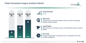
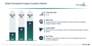
The geospatial imagery analytics market has seen exponential growth in recent years. It is projected to expand from $12.67 billion in 2025 to $16.19 billion in 2026, demonstrating a compound annual growth rate (CAGR) of 27.7%. The market’s historical growth can be attributed to the increasing availability of satellite imagery data, the expansion of urban planning initiatives, the rising use of remote sensing technologies, an increase in defense and security applications, and the adoption of GIS-based analytics tools.
The geospatial imagery analytics market is anticipated to experience substantial expansion over the coming years. Its valuation is projected to reach $42.44 billion by 2030, demonstrating a compound annual growth rate (CAGR) of 27.3%. This projected increase is driven by a heightened need for climate and environmental monitoring, increased investments in smart city initiatives, the broadening scope of disaster management analytics, the expanding application of geospatial intelligence within agriculture, and the greater integration of AI with geospatial platforms. Key developments expected during this period involve a greater embrace of AI-powered image analysis models, increased deployment of satellite and drone imagery, enhanced integration of real-time geospatial data streams, the growth of predictive analytics for risk evaluation, and a stronger emphasis on high-resolution imaging.
Get A Free Sample Report With In-Depth Market Insights:
Geospatial Imagery Analytics Market Opportunity Drivers: What’s Unlocking New Revenue Potential?
The escalating demand for small satellites is projected to propel the expansion of the geospatial imagery analytics market moving forward. These small satellites typically weigh less than 100 kg, often being comparable in size to suitcases. They find application in imagery analytics for scrutinizing minute pieces of information across the globe, delivering more cost-effective, reliable, and accurate results in precise operations. For instance, the National Aeronautics and Space Administration (NASA), a US-based government agency, reported in February 2025 that among the 2,938 total spacecraft launched in 2023, 68% had a mass less than 600 kg, and 27% were under 200 kg in mass. This indicates a 17% increase in total spacecraft launches since 2022, partly attributed to the rise of next-generation SmallSat constellations. Hence, the surge in demand for small satellites is a key driver for the growth of the geospatial imagery analytics market.
Geospatial Imagery Analytics Market Segments: Where Is Growth Concentrated?
The geospatial imagery analytics market covered in this report is segmented –
1) By Type: Video-Based Analytics, Imagery Analytics
2) By Geospatial Technology: Geographical Information Systems (GIS), Remote Sensing (RS)
3) By Deployment Mode: Cloud, On-Premises
4) By Organization Size: Large Enterprises, Small And Medium-Sized Enterprises (SMEs)
5) By Application: Agriculture, Mining And Manufacturing, Defense and Security, Energy, Utility, And Natural Resources, Government, Insurance, Other Applications
Subsegments:
1) By Video-Based Analytics: Real-time Video Processing, Object Detection And Tracking, Pattern Recognition, Event Detection
2) By Imagery Analytics: Satellite Imagery Analysis, Aerial Imagery Analysis, Drone Imagery Analysis, Multispectral And Hyperspectral Imagery Analysis
Geospatial Imagery Analytics Market Innovation Trends Shaping Future Development
Major companies within the geospatial imaging analytics industry are increasingly embracing a strategic partnerships approach to deliver crucial geospatial imaging analytics services to individuals, businesses, and governmental bodies. Strategic partnerships involve companies utilizing each other’s strengths and resources to achieve mutual benefits and success. For instance, in July 2023, Locana, an Italy-based firm specializing in geospatial systems development and location and mapping technology, formed a partnership with OpenStreetMap, a US-based non-profit organization. This collaboration aimed to improve access to high-quality geographic data, lower the cost associated with utilizing location intelligence, and enable more organizations to leverage insights derived from location data. Locana’s alliance with OpenStreetMap US holds significant importance as it provides further backing for the OpenStreetMap project, facilitates access to high-quality geographic data, promotes innovative applications, encourages collaboration, and reflects a growing trend of corporate participation within the OSM community.
Geospatial Imagery Analytics Market Key Participants And Competitive Landscape
Major companies operating in the geospatial imagery analytics market are Planet Labs PBC; Maxar Technologies; Orbital Insight; Descartes Labs; BlackSky Technology; Capella Space; ICEYE; Satellogic; Spire Global; HawkEye 360; Ursa Space Systems; Nearmap; PrecisionHawk; Environmental Systems Research Institute Inc.; Hexagon AB; Trimble Inc.; L3Harris Technologies; Fugro NV; MDA Corporation Ltd.; Satellite Imaging Corporation; SpaceKnow; Geospatial Insight; Upstream Tech
View The Full Geospatial Imagery Analytics Market Report:
Geospatial Imagery Analytics Market Largest Region: Which Geography Holds The Biggest Share?
North America was the largest region in the geospatial imagery analytics market in 2025. The regions covered in the geospatial imagery analytics market report are Asia-Pacific, South East Asia, Western Europe, Eastern Europe, North America, South America, Middle East, Africa.
Reach Out To Our Team:
The Business Research Company: https://www.thebusinessresearchcompany.com/
Americas: +1 310-496-7795
Asia: +44 7882 955267 & +91 8897263534
Europe: +44 7882 955267
Email us at: marketing@tbrc.info
Follow us on:
LinkedIn: https://in.linkedin.com/company/the-business-research-company
YouTube: https://www.youtube.com/channel/UC24_fI0rV8cR5DxlCpgmyFQ
Global Market Model: https://www.thebusinessresearchcompany.com/global-market-model

Wasay has over a decade of experience in market research, data modelling, and analytics, with prior experience at GlobalData and Decision Tree Consulting Services. At The Business Research Company , he leads research operations across syndicated studies, customized consulting engagements, and the Global Market Model platform. His professional experience includes supporting organizations such as Boston Consulting Group, KPMG, and Ernst & Young. Wasay holds a degree in Electronics and Communications Engineering, postgraduate management qualifications from International Management Institute Belgium and Indian School of Business and Entrepreneurship, and completed the Integrated Program in Business Analytics from Indian Institute of Management Indore.