
Built to provide research that’s more actionable and strategically valuable, The Business Research Company’s 2026 market reports include market attractiveness analysis, total addressable market sizing, company benchmarking matrices, interactive Excel dashboards, broader supply chain intelligence, emerging startup tracking, and in-depth product insights.
Drone-Assisted River Pollution Mapping Market Forecast: What Value Will The Market Reach By 2030?
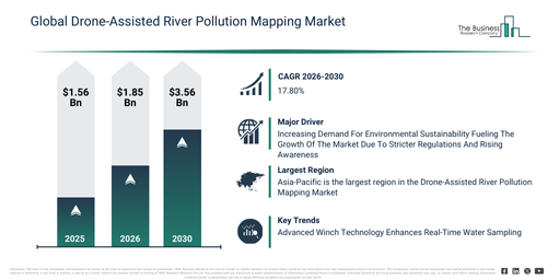
The drone-assisted river pollution mapping market has experienced significant expansion recently. This market is projected to expand from $1.56 billion in 2025 to reach $1.85 billion by 2026, demonstrating a robust compound annual growth rate (CAGR) of 18.6%. Historically, this growth has been driven by heightened anxieties regarding river contamination, the proliferation of environmental observation initiatives, the accessibility of cost-effective drone innovations, the increasing application of remote sensing instruments, and increased capital allocation towards water quality studies.
The market for drone-assisted river pollution mapping is projected to experience substantial expansion in the coming years. This market is anticipated to reach a valuation of $3.56 billion by 2030, demonstrating a compound annual growth rate (CAGR) of 17.8%. Factors contributing to this growth during the projected timeframe include the wider uptake of intelligent environmental monitoring solutions, the broadening application of drone-based enforcement for regulations, the escalating need for current pollution information, the incorporation of predictive analytics into water management practices, and an intensified emphasis on resilient monitoring infrastructure capable of withstanding climate changes. Key trends anticipated during the forecast period encompass the increasing integration of sensors into drones, the growing application of real-time analysis for water quality, the expanding implementation of advanced high-resolution mapping technologies, the development of AI-driven models for pollution detection, and a heightened commitment to ongoing environmental surveillance.
Get A Free Sample Report With In-Depth Market Insights:
Drone-Assisted River Pollution Mapping Market Development Factors: What’s Supporting Demand?
The escalating requirement for environmental sustainability is projected to drive the future expansion of the drone-assisted river pollution mapping market. Environmental sustainability denotes responsible interaction with the environment to safeguard and uphold natural resources for present and future generations. The heightened awareness of environmental sustainability arises from stricter government regulations and policies that enforce compulsory recycling standards and environmentally friendly industrial practices. Drone-assisted river pollution mapping supports environmental sustainability through real-time monitoring of water quality and pollutants, which facilitates easier identification of contamination sources. It reduces the need for manual effort by quickly and accurately covering vast areas, thereby enhancing efficiency in environmental management. For instance, in October 2024, according to the United States Environmental Protection Agency, greenhouse gas emissions increased to 322 million metric tons in 2023, a 1.4% rise compared to 2022. Consequently, the growing demand for environmental sustainability is fostering the growth of the drone-assisted river pollution mapping market.
Drone-Assisted River Pollution Mapping Market Segment Performance And Emerging Opportunities
The drone-assisted river pollution mapping market covered in this report is segmented –
1) By Solution: Hardware, Software, Services
2) By Sensor Type: Optical, Thermal, Light Detection And Ranging (LiDAR), Multispectral, Other Sensor Types
3) By Application: Water Quality Monitoring, Waste Detection, Sediment Analysis, Algal Bloom Detection, Other Applications
4) By End-User: Government Agencies, Environmental Organizations, Research Institutes, Industrial Facilities, Other End-Users
Subsegments:
1) By Hardware: Sensors, Drones, Imaging Devices, Global Positioning System (GPS) Modules, Communication Systems
2) By Software: Data Analytics Platforms, Mapping Software, Remote Monitoring Tools, Artificial Intelligence (AI) Algorithms, Simulation Models
3) By Services: Data Collection, Surveying and Monitoring, Maintenance and Support, Consulting Services, Training and Integration
Drone-Assisted River Pollution Mapping Market Transformation Trends: What Innovations Are Driving Change?
Leading companies in the drone-assisted river pollution mapping market are focusing on developing advanced technological solutions, such as winch technology, to facilitate precise, real-time water sampling in difficult-to-access areas. Winch technology in drones refers to a system that remotely lowers and lifts sensors or equipment during flight, enabling accurate water sampling in rivers or coastal zones for pollution analysis. For example, in January 2024, Skyports Ltd., a UK-based advanced air mobility company, collaborated with Makutu, a UK-based water data analytics firm, to roll out a drone-assisted water quality monitoring service with Northumbrian Water. This endeavor employs electric drones fitted with specialized winch technology to deploy water sensors into rivers and coastal regions, allowing for real-time collection of water quality data. This inventive strategy enables quicker, safer, and more effective monitoring of hard-to-reach sites, reduces the necessity for manual sampling, and provides crucial insights for prompt environmental management and pollution reduction. Furthermore, these drones are capable of beyond visual line of sight (BVLOS) operations, allowing them to cover large expanses in a single flight without returning to base, thus markedly enhancing operational efficiency.
Drone-Assisted River Pollution Mapping Market Key Players: Which Companies Lead Industry Competition?
Major companies operating in the drone-assisted river pollution mapping market report are SZ DJI Technology Co Ltd, Autel Robotics Co Ltd, Saildrone Inc, Microdrones GmbH, OceanAlpha Co Ltd, Delair SAS, AgEagle Aerial Systems Inc, Blueye Robotics AS, WeRobotics, Shenzhen Foxtech Co Ltd, VITO – Flemish Institute for Technological Research, Proteus Instruments Inc, Skyports Drone Services Ltd, Zenadrone Inc, PrecisionHawk Inc, Quantum Systems GmbH, Terra Drone Corporation, Parrot SA, AeroVironment Inc, Skydio Inc
View The Full Drone-Assisted River Pollution Mapping Market Report:
Drone-Assisted River Pollution Mapping Market Geographic Spread And Regional Opportunities
Asia-Pacific was the largest region in the drone-assisted river pollution mapping market in 2025. The regions covered in the drone-assisted river pollution mapping market report are Asia-Pacific, South East Asia, Western Europe, Eastern Europe, North America, South America, Middle East, Africa.
Reach Out To Our Team:
The Business Research Company: https://www.thebusinessresearchcompany.com/
Americas: +1 310-496-7795
Asia: +44 7882 955267 & +91 8897263534
Europe: +44 7882 955267
Email us at: marketing@tbrc.info
Follow us on:
LinkedIn: https://in.linkedin.com/company/the-business-research-company
YouTube: https://www.youtube.com/channel/UC24_fI0rV8cR5DxlCpgmyFQ
Global Market Model: https://www.thebusinessresearchcompany.com/global-market-model

Wasay has over a decade of experience in market research, data modelling, and analytics, with prior experience at GlobalData and Decision Tree Consulting Services. At The Business Research Company , he leads research operations across syndicated studies, customized consulting engagements, and the Global Market Model platform. His professional experience includes supporting organizations such as Boston Consulting Group, KPMG, and Ernst & Young. Wasay holds a degree in Electronics and Communications Engineering, postgraduate management qualifications from International Management Institute Belgium and Indian School of Business and Entrepreneurship, and completed the Integrated Program in Business Analytics from Indian Institute of Management Indore.