Designed to make market research more actionable and strategically valuable, The Business Research Company’s 2026 market reports feature market attractiveness scoring, total addressable market sizing, company benchmarking matrices, interactive Excel dashboards, deeper supply chain intelligence, emerging startup tracking, and granular product-level insights.
How Fast Is The Commercial Satellite Imaging Market Growing? Market Size, CAGR And Forecast Insights
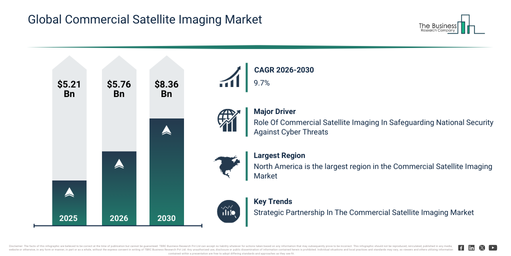
The commercial satellite imaging market has experienced significant growth in recent years. This market is projected to expand from $5.21 billion in 2025 to $5.76 billion in 2026, exhibiting a compound annual growth rate (CAGR) of 10.7%. Historically, this expansion can be attributed to several factors: increased demand for high-resolution satellite imagery for mapping and land-use analysis, a rise in the application of multispectral and hyperspectral imaging for environmental monitoring, the growing adoption of satellite data in disaster response and assessment, the expansion of commercial satellite constellations leading to improved imaging frequency, and the development of online mapping tools that facilitate easier access to satellite imagery.
The commercial satellite imaging market size is projected for substantial expansion over the next few years. It is forecast to reach $8.36 billion by 2030, exhibiting a compound annual growth rate (CAGR) of 9.7%. This growth during the forecast period is primarily driven by the increasing need for real-time and continuous earth observation data across various sectors, the rising deployment of smallsat and cubesat imaging constellations, advancements in image analytics and AI-driven geospatial interpretation, the growing adoption of satellite imaging for climate monitoring and sustainability applications, and the expansion of commercial services offering integrated imaging, data layering, and bulk mapping capabilities. Significant trends expected in this period include the rising demand for ultra-high-resolution satellite imagery, increasing commercial use of multispectral and hyperspectral imaging, the growing adoption of satellite data for disaster prediction and response, the expansion of cloud-based satellite analytics platforms, and an increasing demand for satellite imaging in precision agriculture.
Unlock Commercial Satellite Imaging Market Insights With A Free Sample Report:
Commercial Satellite Imaging Market Momentum: Key Driver Expected To Boost Growth Through 2030
Growing worries about national security are projected to boost the commercial satellite imaging market in the future. National security threats encompass any activities or occurrences that endanger a nation’s or its populace’s safety, stability, and security. Such threats may stem from diverse origins, such as foreign governments, terrorist groups, or cyber intrusions targeting government entities. Data from satellite imaging offers a supporting function in averting cyber-attacks on government agencies, delivering crucial insights for network oversight, geographic location identification, preliminary alerts, crisis management, and containment strategies. As an illustration, in November 2023, the 2023 ASD Cyber Threat Report from the Australian Signals Directorate, an Australian federal body, revealed that during the 2022-23 fiscal year, ReportCyber documented almost 94,000 cybercrime reports, indicating a 23% increase over the preceding financial year. Consequently, the heightened apprehension regarding national security is fueling the commercial satellite imaging market.
Commercial Satellite Imaging Market Segments: A Category-By-Category Overview
The commercial satellite imaging market covered in this report is segmented –
1) By Technology: Optical, Radar
2) By Application: Geospatial Data Acquisition And Mapping, Natural Resource Management, Surveillance And Security, Conservation And Research, Disaster Management, Defense And Intelligence
3) By End User: Government, Military And Defense, Forestry And Agriculture, Energy, Civil Engineering And Archaeology, Transportation And Logistics, Other End Users
Subsegments:
1) By Optical: High-Resolution Optical Imaging, Multispectral Imaging, Hyperspectral Imaging
2) By Radar: Synthetic Aperture Radar (SAR), Interferometric Synthetic Aperture Radar (InSAR)
Which Emerging Trends Are Gaining Traction In The Commercial Satellite Imaging Market?
Major companies operating in the commercial satellite imaging market are adopting a strategic partnership approach to enhance the use of satellite imagery. Strategic partnerships signify a process where organizations leverage each other’s strengths and resources to achieve mutual benefits and success. For instance, in April 2023, Axelspace, a Japan-based space startup developing microsatellite technology, collaborated with New Space Intelligence, a Japan-based provider of satellite imagery analysis services. As a result of this collaboration, the companies will jointly drive the increased utilization of satellite data. Emphasizing the development of novel applications and the extension of services to international markets will be central to their combined efforts. This strategic partnership significantly broadens Axelspace’s presence in innovative satellite image applications.
Commercial Satellite Imaging Market Key Participants: Prominent Companies At A Glance
Major companies operating in the commercial satellite imaging market are Airbus SE, L3Harris Technologies Inc., Maxar Technologies Inc., DigitalGlobe Inc., Telespazio Spa, MDA Ltd., Planet Labs PBC, Radiant Solutions Inc., Spire Global Inc., Capella Space Inc., BlackSky Global LLC, GHGSat Inc., ImageSat International N.V. (iSi), UrtheCast Corp., Orbital Insight Inc., Descartes Labs Inc., Satellogic S.L.U., SpaceKnow Inc., Kleos Space S.A., European Space Imaging (EUSI) GmbH, Galileo Group Inc., Skylab Analytics, ICEYE Finland Oy, Satshots LLC, Predicio Analytics Inc.
Get Detailed Commercial Satellite Imaging Market Forecasts In The Complete Report:
Top Region In The Commercial Satellite Imaging Market: A Global Perspective
North America was the largest region in the commercial satellite imaging market in 2025. Asia-Pacific is expected to be the fastest-growing region in the global commercial satellite imaging market report during the forecast period. The regions covered in the commercial satellite imaging market report are Asia-Pacific, South East Asia, Western Europe, Eastern Europe, North America, South America, Middle East, Africa.
Reach Out To Our Team:
The Business Research Company: https://www.thebusinessresearchcompany.com/
Americas: +1 310-496-7795
Asia: +44 7882 955267 & +91 8897263534
Europe: +44 7882 955267
Email us at: marketing@tbrc.info
Follow us on:
LinkedIn: https://in.linkedin.com/company/the-business-research-company
YouTube: https://www.youtube.com/channel/UC24_fI0rV8cR5DxlCpgmyFQ
Global Market Model: https://www.thebusinessresearchcompany.com/global-market-model

Wasay has over a decade of experience in market research, data modelling, and analytics, with prior experience at GlobalData and Decision Tree Consulting Services. At The Business Research Company , he leads research operations across syndicated studies, customized consulting engagements, and the Global Market Model platform. His professional experience includes supporting organizations such as Boston Consulting Group, KPMG, and Ernst & Young. Wasay holds a degree in Electronics and Communications Engineering, postgraduate management qualifications from International Management Institute Belgium and Indian School of Business and Entrepreneurship, and completed the Integrated Program in Business Analytics from Indian Institute of Management Indore.